Rockdale geodata
Rockdale (Texas) is a populated place; located in United States in America/Chicago (GMT-5) time zone. With population of 5,609 people, there are 6674 cities with bigger population in this country. Compared to other cities in United States, 91.4% of cities are located further ↑North; 75.7% of cities are located further →East and 61.7% of cities have higher elevation than Rockdale. Note1


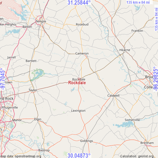
Rockdale GPS coordinates[2]
30° 39' 19.728" North, 97° 0' 4.932" West
| Map corner | latitude | longitude |
|---|---|---|
| Upper-left | 31.25844°, | -97.7045° |
| Center: | 30.65548°, | -97.00137° |
| Lower-right: | 30.04873°, | -96.29825° |
| Map W x H: | 134.5×134.5 km | = 83.6×83.6mi |
| max Lat: | 71.29058° ⇑91.4% North |
| Rockdale: | 30.65548° |
| min Lat: | ⇓8.6% South 19.06759° |
| min Long | Rockdale | max Long |
| -171.73463° | -97.00137° | -66.98998° |
| W 24.3%⇐ | ⇒75.7% E |
Elevation
Elevation of Rockdale is 146 m = 479 ft, and this is 148.8 m = 488 ft below average elevation for this country.
| Max E: |
3189 m = 10463 ft | 61.7% |
| Avg. | 294.8 m = 967 ft | |
| Rockdale | 146 m = 479 ft | |
Min E: |
-60 m = -197 ft | 38.3% |
See also: United States elevation on elevation.city.
Geographical zone
Rockdale is located in North temperate zone (between Tropic of Cancer and the Arctic Circle). Distance of this Northern Tropic circle is 802.7 km =498.8 mi to South.| Distance of | km | miles | from Rockdale |
|---|---|---|---|
| North Pole | 6598.5 | 4100.1 | to North |
| Arctic Circle | 3992.6 | 2480.9 | to North |
| Tropic Cancer | 802.7 | 498.8 | to South |
| Equator | 3408.6 | 2118 | to South |


Nearby cities:
15 places around Rockdale: (largest is in red/bold)
• Bartlett
43.4 km =27 mi,  290°
290°
• Buckholts
26.9 km =16.7 mi,  333°
333°
• Caldwell
32.6 km =20.3 mi,  115°
115°
• Cameron
22.1 km =13.7 mi,  6°
6°
• Granger
42.8 km =26.6 mi,  279°
279°
• Hearne
46.2 km =28.7 mi,  57°
57°
• Holland
45.6 km =28.3 mi,  302°
302°
• Lexington
26.3 km =16.3 mi,  182°
182°
• McDade
47.1 km =29.3 mi,  208°
208°
• Rogers
37.5 km =23.3 mi,  324°
324°
• Rosebud
46.5 km =28.9 mi,  2°
2°
• Sparks
45.8 km =28.5 mi,  311°
311°
• Taylor
40.2 km =25 mi,  256°
256°
• Thorndale
20.1 km =12.5 mi, 256°
• Thrall
29.2 km =18.1 mi, 255°
Sources, notices
• [Note1] Compared only with cities in United States existing in our database
• [Src1] Map data: © OpenStreetMap contributors (CC-BY-SA)
• [Src2] Other city data from geonames.org with taken over terms of usage.
• [Src3] Geographical zone / Annual Mean Temperature by Robert A. Rohde @ Wikipedia
