Caldwell geodata
Caldwell (Texas) is a seat of a second-order administrative division; located in United States in America/Chicago (GMT-5) time zone. With population of 4,283 people, there are 7883 cities with bigger population in this country. Compared to other cities in United States, 91.7% of cities are located further ↑North; 74.9% of cities are located further →East and 66% of cities have higher elevation than Caldwell. Note1


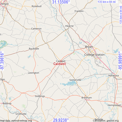
Caldwell GPS coordinates[2]
30° 31' 52.752" North, 96° 41' 34.908" West
| Map corner | latitude | longitude |
|---|---|---|
| Upper-left | 31.13506°, | -97.39616° |
| Center: | 30.53132°, | -96.69303° |
| Lower-right: | 29.9238°, | -95.98991° |
| Map W x H: | 134.7×134.7 km | = 83.7×83.7mi |
| max Lat: | 71.29058° ⇑91.7% North |
| Caldwell: | 30.53132° |
| min Lat: | ⇓8.3% South 19.06759° |
| min Long | Caldwell | max Long |
| -171.73463° | -96.69303° | -66.98998° |
| W 25.1%⇐ | ⇒74.9% E |
Elevation
Elevation of Caldwell is 123 m = 404 ft, and this is 171.8 m = 564 ft below average elevation for this country.
| Max E: |
3189 m = 10463 ft | 66% |
| Avg. | 294.8 m = 967 ft | |
| Caldwell | 123 m = 404 ft | |
Min E: |
-60 m = -197 ft | 34% |
See also: United States elevation on elevation.city.
Geographical zone
Caldwell is located in North temperate zone (between Tropic of Cancer and the Arctic Circle). Distance of this Northern Tropic circle is 788.8 km =490.1 mi to South.| Distance of | km | miles | from Caldwell |
|---|---|---|---|
| North Pole | 6612.3 | 4108.7 | to North |
| Arctic Circle | 4006.4 | 2489.5 | to North |
| Tropic Cancer | 788.8 | 490.1 | to South |
| Equator | 3394.8 | 2109.4 | to South |


Nearby cities:
15 places around Caldwell: (largest is in red/bold)
• Brenham
49.4 km =30.7 mi,  145°
145°
• Bryan
34.8 km =21.6 mi,  62°
62°
• Buckholts
56.1 km =34.9 mi,  312°
312°
• Calvert
49.7 km =30.9 mi,  2°
2°
• Cameron
44.9 km =27.9 mi,  322°
322°
• College Station
36 km =22.4 mi,  72°
72°
• Franklin
58.5 km =36.4 mi,  19°
19°
• Giddings
45.2 km =28.1 mi,  211°
211°
• Hearne
39.8 km =24.7 mi,  13°
13°
• Lexington
33 km =20.5 mi,  247°
247°
• Rockdale
32.6 km =20.3 mi,  295°
295°
• Snook
22.3 km =13.9 mi,  102°
102°
• Somerville
26 km =16.2 mi,  142°
142°
• Thorndale
49.9 km =31 mi,  280°
280°
• Thrall
58.2 km =36.2 mi, 276°
Sources, notices
• [Note1] Compared only with cities in United States existing in our database
• [Src1] Map data: © OpenStreetMap contributors (CC-BY-SA)
• [Src2] Other city data from geonames.org with taken over terms of usage.
• [Src3] Geographical zone / Annual Mean Temperature by Robert A. Rohde @ Wikipedia
