Thrall geodata
Thrall (Texas) is a populated place; located in United States in America/Chicago (GMT-5) time zone. With population of 920 people, there are 16868 cities with bigger population in this country. Compared to other cities in United States, 91.5% of cities are located further ↑North; 76.6% of cities are located further →East and 56.6% of cities have higher elevation than Thrall. Note1


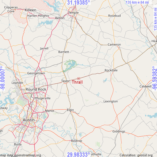
Thrall GPS coordinates[2]
30° 35' 25.728" North, 97° 17' 48.984" West
| Map corner | latitude | longitude |
|---|---|---|
| Upper-left | 31.19385°, | -98.00007° |
| Center: | 30.59048°, | -97.29694° |
| Lower-right: | 29.98333°, | -96.59382° |
| Map W x H: | 134.6×134.6 km | = 83.6×83.6mi |
| max Lat: | 71.29058° ⇑91.5% North |
| Thrall: | 30.59048° |
| min Lat: | ⇓8.5% South 19.06759° |
| min Long | Thrall | max Long |
| -171.73463° | -97.29694° | -66.98998° |
| W 23.4%⇐ | ⇒76.6% E |
Elevation
Elevation of Thrall is 173 m = 568 ft, and this is 121.8 m = 400 ft below average elevation for this country.
| Max E: |
3189 m = 10463 ft | 56.6% |
| Avg. | 294.8 m = 967 ft | |
| Thrall | 173 m = 568 ft | |
Min E: |
-60 m = -197 ft | 43.4% |
See also: United States elevation on elevation.city.
Geographical zone
Thrall is located in North temperate zone (between Tropic of Cancer and the Arctic Circle). Distance of this Northern Tropic circle is 795.4 km =494.2 mi to South.| Distance of | km | miles | from Thrall |
|---|---|---|---|
| North Pole | 6605.7 | 4104.6 | to North |
| Arctic Circle | 3999.8 | 2485.4 | to North |
| Tropic Cancer | 795.4 | 494.2 | to South |
| Equator | 3401.3 | 2113.5 | to South |


Nearby cities:
15 places around Thrall: (largest is in red/bold)
• Bartlett
25.8 km =16 mi,  331°
331°
• Buckholts
35.4 km =22 mi,  27°
27°
• Elgin
27.7 km =17.2 mi,  194°
194°
• Georgetown
36.7 km =22.8 mi,  277°
277°
• Granger
19.9 km =12.4 mi,  315°
315°
• Holland
33.5 km =20.8 mi,  342°
342°
• Hutto
24.5 km =15.2 mi,  257°
257°
• Lexington
33.3 km =20.7 mi,  124°
124°
• Manor
37.3 km =23.2 mi,  221°
221°
• McDade
34.6 km =21.5 mi,  170°
170°
• Pflugerville
35.2 km =21.9 mi,  241°
241°
• Rockdale
29.2 km =18.1 mi,  75°
75°
• Taylor
11 km =6.8 mi, 258°
• Thorndale
9.1 km =5.7 mi,  73°
73°
• Windemere
36.8 km =22.9 mi,  246°
246°
Sources, notices
• [Note1] Compared only with cities in United States existing in our database
• [Src1] Map data: © OpenStreetMap contributors (CC-BY-SA)
• [Src2] Other city data from geonames.org with taken over terms of usage.
• [Src3] Geographical zone / Annual Mean Temperature by Robert A. Rohde @ Wikipedia
