Cameron geodata
Cameron (Texas) is a seat of a second-order administrative division; located in United States in America/Chicago (GMT-5) time zone. With population of 5,460 people, there are 6796 cities with bigger population in this country. Compared to other cities in United States, 91% of cities are located further ↑North; 75.6% of cities are located further →East and 65.2% of cities have higher elevation than Cameron. Note1


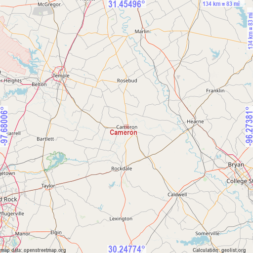
Cameron GPS coordinates[2]
30° 51' 11.7" North, 96° 58' 36.948" West
| Map corner | latitude | longitude |
|---|---|---|
| Upper-left | 31.45496°, | -97.68006° |
| Center: | 30.85325°, | -96.97693° |
| Lower-right: | 30.24774°, | -96.27381° |
| Map W x H: | 134.2×134.2 km | = 83.4×83.4mi |
| max Lat: | 71.29058° ⇑91% North |
| Cameron: | 30.85325° |
| min Lat: | ⇓9% South 19.06759° |
| min Long | Cameron | max Long |
| -171.73463° | -96.97693° | -66.98998° |
| W 24.4%⇐ | ⇒75.6% E |
Elevation
Elevation of Cameron is 127 m = 417 ft, and this is 167.8 m = 551 ft below average elevation for this country.
| Max E: |
3189 m = 10463 ft | 65.2% |
| Avg. | 294.8 m = 967 ft | |
| Cameron | 127 m = 417 ft | |
Min E: |
-60 m = -197 ft | 34.8% |
See also: United States elevation on elevation.city.
Geographical zone
Cameron is located in North temperate zone (between Tropic of Cancer and the Arctic Circle). Distance of this Northern Tropic circle is 824.6 km =512.4 mi to South.| Distance of | km | miles | from Cameron |
|---|---|---|---|
| North Pole | 6576.5 | 4086.4 | to North |
| Arctic Circle | 3970.6 | 2467.2 | to North |
| Tropic Cancer | 824.6 | 512.4 | to South |
| Equator | 3430.6 | 2131.7 | to South |


Nearby cities:
15 places around Cameron: (largest is in red/bold)
• Bartlett
43.3 km =26.9 mi,  261°
261°
• Bremond
44.9 km =27.9 mi,  39°
39°
• Buckholts
14.3 km =8.9 mi,  278°
278°
• Calvert
32.1 km =19.9 mi,  64°
64°
• Hearne
36.7 km =22.8 mi,  85°
85°
• Holland
40.6 km =25.2 mi,  273°
273°
• Little River-Academy
39.3 km =24.4 mi,  292°
292°
• Lott
39.4 km =24.5 mi,  351°
351°
• Rockdale
22.1 km =13.7 mi,  186°
186°
• Rogers
25.4 km =15.8 mi, 290°
• Rosebud
24.4 km =15.2 mi,  359°
359°
• Sparks
37.5 km =23.3 mi, 282°
• Temple
44.3 km =27.5 mi,  307°
307°
• Thorndale
34.4 km =21.4 mi,  219°
219°
• Thrall
42.3 km =26.3 mi,  226°
226°
Sources, notices
• [Note1] Compared only with cities in United States existing in our database
• [Src1] Map data: © OpenStreetMap contributors (CC-BY-SA)
• [Src2] Other city data from geonames.org with taken over terms of usage.
• [Src3] Geographical zone / Annual Mean Temperature by Robert A. Rohde @ Wikipedia
