Thorndale geodata
Thorndale (Texas) is a populated place; located in United States in America/Chicago (GMT-5) time zone. With population of 1,316 people, there are 14516 cities with bigger population in this country. Compared to other cities in United States, 91.5% of cities are located further ↑North; 76.3% of cities are located further →East and 62.6% of cities have higher elevation than Thorndale. Note1


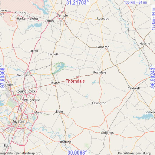
Thorndale GPS coordinates[2]
30° 36' 49.716" North, 97° 12' 19.98" West
| Map corner | latitude | longitude |
|---|---|---|
| Upper-left | 31.21703°, | -97.90868° |
| Center: | 30.61381°, | -97.20555° |
| Lower-right: | 30.0068°, | -96.50243° |
| Map W x H: | 134.6×134.6 km | = 83.6×83.6mi |
| max Lat: | 71.29058° ⇑91.5% North |
| Thorndale: | 30.61381° |
| min Lat: | ⇓8.5% South 19.06759° |
| min Long | Thorndale | max Long |
| -171.73463° | -97.20555° | -66.98998° |
| W 23.7%⇐ | ⇒76.3% E |
Elevation
Elevation of Thorndale is 141 m = 463 ft, and this is 153.8 m = 505 ft below average elevation for this country.
| Max E: |
3189 m = 10463 ft | 62.6% |
| Avg. | 294.8 m = 967 ft | |
| Thorndale | 141 m = 463 ft | |
Min E: |
-60 m = -197 ft | 37.4% |
See also: United States elevation on elevation.city.
Geographical zone
Thorndale is located in North temperate zone (between Tropic of Cancer and the Arctic Circle). Distance of this Northern Tropic circle is 798 km =495.9 mi to South.| Distance of | km | miles | from Thorndale |
|---|---|---|---|
| North Pole | 6603.1 | 4103 | to North |
| Arctic Circle | 3997.2 | 2483.7 | to North |
| Tropic Cancer | 798 | 495.9 | to South |
| Equator | 3403.9 | 2115.1 | to South |


Nearby cities:
15 places around Thorndale: (largest is in red/bold)
• Bartlett
29.1 km =18.1 mi,  313°
313°
• Buckholts
29.8 km =18.5 mi,  14°
14°
• Cameron
34.4 km =21.4 mi,  39°
39°
• Elgin
33.3 km =20.7 mi,  208°
208°
• Granger
25.5 km =15.8 mi,  296°
296°
• Holland
34.9 km =21.7 mi,  327°
327°
• Hutto
33.6 km =20.9 mi,  256°
256°
• Lexington
28.5 km =17.7 mi,  139°
139°
• Little River-Academy
43.9 km =27.3 mi,  340°
340°
• McDade
36.8 km =22.9 mi,  184°
184°
• Rockdale
20.1 km =12.5 mi,  76°
76°
• Rogers
35.4 km =22 mi,  356°
356°
• Sparks
38 km =23.6 mi, 337°
• Taylor
20.1 km =12.5 mi, 256°
• Thrall
9.1 km =5.7 mi,  253°
253°
Sources, notices
• [Note1] Compared only with cities in United States existing in our database
• [Src1] Map data: © OpenStreetMap contributors (CC-BY-SA)
• [Src2] Other city data from geonames.org with taken over terms of usage.
• [Src3] Geographical zone / Annual Mean Temperature by Robert A. Rohde @ Wikipedia
