Elgin geodata
Elgin (Texas) is a populated place; located in United States in America/Chicago (GMT-5) time zone. With population of 9,039 people, there are 4789 cities with bigger population in this country. Compared to other cities in United States, 92.4% of cities are located further ↑North; 76.8% of cities are located further →East and 55.1% of cities have higher elevation than Elgin. Note1


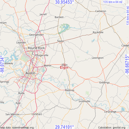
Elgin GPS coordinates[2]
30° 20' 58.74" North, 97° 22' 12.972" West
| Map corner | latitude | longitude |
|---|---|---|
| Upper-left | 30.95453°, | -98.0734° |
| Center: | 30.34965°, | -97.37027° |
| Lower-right: | 29.74101°, | -96.66715° |
| Map W x H: | 134.9×134.9 km | = 83.8×83.8mi |
| max Lat: | 71.29058° ⇑92.4% North |
| Elgin: | 30.34965° |
| min Lat: | ⇓7.6% South 19.06759° |
| min Long | Elgin | max Long |
| -171.73463° | -97.37027° | -66.98998° |
| W 23.2%⇐ | ⇒76.8% E |
Elevation
Elevation of Elgin is 180 m = 591 ft, and this is 114.8 m = 377 ft below average elevation for this country.
| Max E: |
3189 m = 10463 ft | 55.1% |
| Avg. | 294.8 m = 967 ft | |
| Elgin | 180 m = 591 ft | |
Min E: |
-60 m = -197 ft | 44.9% |
See also: United States elevation on elevation.city.
Geographical zone
Elgin is located in North temperate zone (between Tropic of Cancer and the Arctic Circle). Distance of this Northern Tropic circle is 768.6 km =477.6 mi to South.| Distance of | km | miles | from Elgin |
|---|---|---|---|
| North Pole | 6632.5 | 4121.2 | to North |
| Arctic Circle | 4026.6 | 2502 | to North |
| Tropic Cancer | 768.6 | 477.6 | to South |
| Equator | 3374.6 | 2096.9 | to South |


Nearby cities:
15 places around Elgin: (largest is in red/bold)
• Bastrop
27.1 km =16.8 mi,  168°
168°
• Camp Swift
19.2 km =11.9 mi,  157°
157°
• Circle D-KC Estates
24.7 km =15.3 mi,  148°
148°
• Garfield
25.5 km =15.8 mi,  224°
224°
• Hornsby Bend
23.4 km =14.5 mi,  240°
240°
• Hutto
27.3 km =17 mi,  321°
321°
• Manor
17.9 km =11.1 mi,  266°
266°
• McDade
14.7 km =9.1 mi,  119°
119°
• Pflugerville
25.9 km =16.1 mi,  292°
292°
• Taylor
24.9 km =15.5 mi,  351°
351°
• Thorndale
33.3 km =20.7 mi,  28°
28°
• Thrall
27.7 km =17.2 mi,  14°
14°
• Wells Branch
31.5 km =19.6 mi, 289°
• Windemere
29.4 km =18.3 mi, 294°
• Wyldwood
26.4 km =16.4 mi,  201°
201°
Sources, notices
• [Note1] Compared only with cities in United States existing in our database
• [Src1] Map data: © OpenStreetMap contributors (CC-BY-SA)
• [Src2] Other city data from geonames.org with taken over terms of usage.
• [Src3] Geographical zone / Annual Mean Temperature by Robert A. Rohde @ Wikipedia
