Keene geodata
Keene (Texas) is a populated place; located in United States in America/Chicago (GMT-5) time zone. With population of 6,181 people, there are 6279 cities with bigger population in this country. Compared to other cities in United States, 87.5% of cities are located further ↑North; 76.6% of cities are located further →East and 68.7% of cities have lower elevation than Keene. Note1


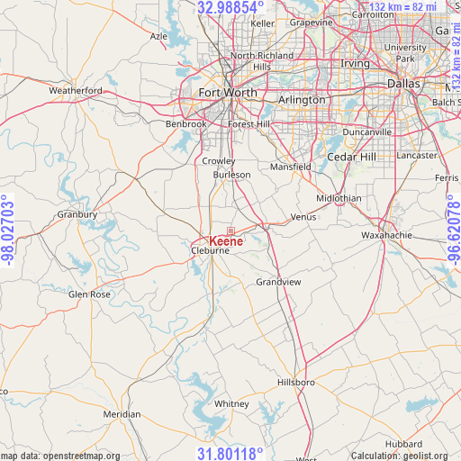
Keene GPS coordinates[2]
32° 23' 48.516" North, 97° 19' 26.04" West
| Map corner | latitude | longitude |
|---|---|---|
| Upper-left | 32.98854°, | -98.02703° |
| Center: | 32.39681°, | -97.3239° |
| Lower-right: | 31.80118°, | -96.62078° |
| Map W x H: | 132×132 km | = 82×82mi |
| max Lat: | 71.29058° ⇑87.5% North |
| Keene: | 32.39681° |
| min Lat: | ⇓12.5% South 19.06759° |
| min Long | Keene | max Long |
| -171.73463° | -97.3239° | -66.98998° |
| W 23.4%⇐ | ⇒76.6% E |
Elevation
Elevation of Keene is 279 m = 915 ft, and this is 15.8 m = 52 ft below average elevation for this country.
| Max E: |
3189 m = 10463 ft | 31.3% |
| Avg. | 294.8 m = 967 ft | |
| Keene | 279 m = 915 ft | |
Min E: |
-60 m = -197 ft | 68.7% |
See also: United States elevation on elevation.city.
Geographical zone
Keene is located in North temperate zone (between Tropic of Cancer and the Arctic Circle). Distance of this Northern Tropic circle is 996.3 km =619.1 mi to South.| Distance of | km | miles | from Keene |
|---|---|---|---|
| North Pole | 6404.9 | 3979.8 | to North |
| Arctic Circle | 3799 | 2360.6 | to North |
| Tropic Cancer | 996.3 | 619.1 | to South |
| Equator | 3602.2 | 2238.3 | to South |


Nearby cities:
15 places around Keene: (largest is in red/bold)
• Alvarado
10.6 km =6.6 mi,  84°
84°
• Burleson
16.2 km =10.1 mi,  1°
1°
• Cleburne
8 km =5 mi,  227°
227°
• Crowley
20.6 km =12.8 mi,  349°
349°
• Edgecliff Village
29.1 km =18.1 mi,  356°
356°
• Everman
26.2 km =16.3 mi,  7°
7°
• Godley
19.9 km =12.4 mi,  286°
286°
• Grandview
19.6 km =12.2 mi,  135°
135°
• Joshua
9.4 km =5.8 mi,  320°
320°
• Kennedale
29.3 km =18.2 mi,  18°
18°
• Mansfield
25.2 km =15.7 mi,  42°
42°
• Maypearl
30.8 km =19.1 mi,  107°
107°
• Rendon
21.4 km =13.3 mi, 21°
• Rio Vista
18.8 km =11.7 mi,  194°
194°
• Venus
21.2 km =13.2 mi, 78°
Sources, notices
• [Note1] Compared only with cities in United States existing in our database
• [Src1] Map data: © OpenStreetMap contributors (CC-BY-SA)
• [Src2] Other city data from geonames.org with taken over terms of usage.
• [Src3] Geographical zone / Annual Mean Temperature by Robert A. Rohde @ Wikipedia
