Lynchburg geodata
Lynchburg (Virginia) is a seat of a second-order administrative division; located in United States in America/New_York (GMT-4) time zone. With population of 79,812 people, there are 497 cities with bigger population in this country. Compared to other cities in United States, 64.4% of cities are located further ↑North; 75.5% of cities are located further ←West and 50.2% of cities have lower elevation than Lynchburg. Note1


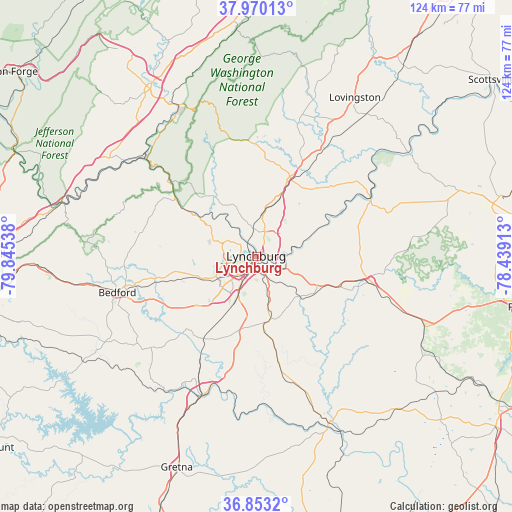
Lynchburg GPS coordinates[2]
37° 24' 49.5" North, 79° 8' 32.1" West
| Map corner | latitude | longitude |
|---|---|---|
| Upper-left | 37.97013°, | -79.84538° |
| Center: | 37.41375°, | -79.14225° |
| Lower-right: | 36.8532°, | -78.43913° |
| Map W x H: | 124.2×124.2 km | = 77.2×77.2mi |
| max Lat: | 71.29058° ⇑64.4% North |
| Lynchburg: | 37.41375° |
| min Lat: | ⇓35.6% South 19.06759° |
| min Long | Lynchburg | max Long |
| -171.73463° | -79.14225° | -66.98998° |
| W 75.5%⇐ | ⇒24.5% E |
Elevation
Elevation of Lynchburg is 199 m = 653 ft, and this is 95.8 m = 314 ft below average elevation for this country.
| Max E: |
3189 m = 10463 ft | 49.8% |
| Avg. | 294.8 m = 967 ft | |
| Lynchburg | 199 m = 653 ft | |
Min E: |
-60 m = -197 ft | 50.2% |
See also: Lynchburg elevation on elevation.city.
Geographical zone
Lynchburg is located in North temperate zone (between Tropic of Cancer and the Arctic Circle). Distance of this Northern Tropic circle is 1554.1 km =965.7 mi to South.| Distance of | km | miles | from Lynchburg |
|---|---|---|---|
| North Pole | 5847 | 3633.2 | to North |
| Arctic Circle | 3241.2 | 2014 | to North |
| Tropic Cancer | 1554.1 | 965.7 | to South |
| Equator | 4160 | 2584.9 | to South |


Nearby cities:
15 places around Lynchburg: (largest is in red/bold)
• Altavista
35.9 km =22.3 mi,  200°
200°
• Amherst
20.7 km =12.9 mi,  22°
22°
• Appomattox
28.7 km =17.8 mi,  102°
102°
• Arrington
36.8 km =22.9 mi,  35°
35°
• Bedford
34.8 km =21.6 mi,  255°
255°
• Buena Vista
40.2 km =25 mi,  332°
332°
• Concord
16.8 km =10.4 mi,  118°
118°
• Forest
14.2 km =8.8 mi,  246°
246°
• Glasgow
36.6 km =22.7 mi,  312°
312°
• Hurt
38.2 km =23.7 mi, 200°
• Madison Heights
2.6 km =1.6 mi, 41°
• Motley
42.1 km =26.2 mi, 204°
• Rustburg
15.7 km =9.8 mi,  166°
166°
• Timberlake
14.5 km =9 mi,  224°
224°
• West Lynchburg
3.4 km =2.1 mi, 249°
Sources, notices
• [Note1] Compared only with cities in United States existing in our database
• [Src1] Map data: © OpenStreetMap contributors (CC-BY-SA)
• [Src2] Other city data from geonames.org with taken over terms of usage.
• [Src3] Geographical zone / Annual Mean Temperature by Robert A. Rohde @ Wikipedia
