Danville geodata
Danville (West Virginia) is a populated place; located in United States in America/New_York (GMT-4) time zone. With population of 655 people, there are 19138 cities with bigger population in this country. Compared to other cities in United States, 61.2% of cities are located further ↑North; 66.2% of cities are located further ←West and 53.5% of cities have lower elevation than Danville. Note1


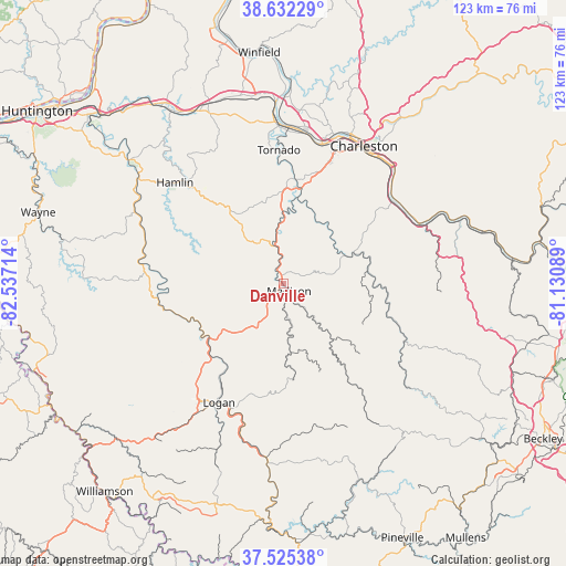
Danville GPS coordinates[2]
38° 4' 51.348" North, 81° 50' 2.436" West
| Map corner | latitude | longitude |
|---|---|---|
| Upper-left | 38.63229°, | -82.53714° |
| Center: | 38.08093°, | -81.83401° |
| Lower-right: | 37.52538°, | -81.13089° |
| Map W x H: | 123.1×123.1 km | = 76.5×76.5mi |
| max Lat: | 71.29058° ⇑61.2% North |
| Danville: | 38.08093° |
| min Lat: | ⇓38.8% South 19.06759° |
| min Long | Danville | max Long |
| -171.73463° | -81.83401° | -66.98998° |
| W 66.2%⇐ | ⇒33.8% E |
Elevation
Elevation of Danville is 212 m = 696 ft, and this is 82.8 m = 272 ft below average elevation for this country.
| Max E: |
3189 m = 10463 ft | 46.5% |
| Avg. | 294.8 m = 967 ft | |
| Danville | 212 m = 696 ft | |
Min E: |
-60 m = -197 ft | 53.5% |
See also: United States elevation on elevation.city.
Geographical zone
Danville is located in North temperate zone (between Tropic of Cancer and the Arctic Circle). Distance of this Northern Tropic circle is 1628.3 km =1011.8 mi to South.| Distance of | km | miles | from Danville |
|---|---|---|---|
| North Pole | 5772.9 | 3587.1 | to North |
| Arctic Circle | 3167 | 1967.9 | to North |
| Tropic Cancer | 1628.3 | 1011.8 | to South |
| Equator | 4234.2 | 2631 | to South |


Nearby cities:
15 places around Danville: (largest is in red/bold)
• Alum Creek
23 km =14.3 mi,  6°
6°
• Belle
30.9 km =19.2 mi,  57°
57°
• Chapmanville
20 km =12.4 mi,  233°
233°
• Chelyan
32.6 km =20.3 mi,  67°
67°
• Chesapeake
30.5 km =19 mi, 58°
• Dunbar
32.2 km =20 mi,  15°
15°
• Hamlin
32.2 km =20 mi,  313°
313°
• Harts
26.4 km =16.4 mi,  257°
257°
• Logan
29.4 km =18.3 mi,  208°
208°
• Madison
2 km =1.2 mi,  140°
140°
• Marmet
29.6 km =18.4 mi,  51°
51°
• McConnell
30.7 km =19.1 mi,  202°
202°
• Mount Gay-Shamrock
31.9 km =19.8 mi, 212°
• Rand
32.7 km =20.3 mi, 46°
• Tornado
29.1 km =18.1 mi,  358°
358°
Sources, notices
• [Note1] Compared only with cities in United States existing in our database
• [Src1] Map data: © OpenStreetMap contributors (CC-BY-SA)
• [Src2] Other city data from geonames.org with taken over terms of usage.
• [Src3] Geographical zone / Annual Mean Temperature by Robert A. Rohde @ Wikipedia
