Danbury geodata
Danbury (Connecticut) is a populated place; located in United States in America/New_York (GMT-4) time zone. With population of 84,657 people, there are 457 cities with bigger population in this country. Compared to other cities in United States, 69.7% of cities are located further ↓South; 92.9% of cities are located further ←West and 65.5% of cities have higher elevation than Danbury. Note1


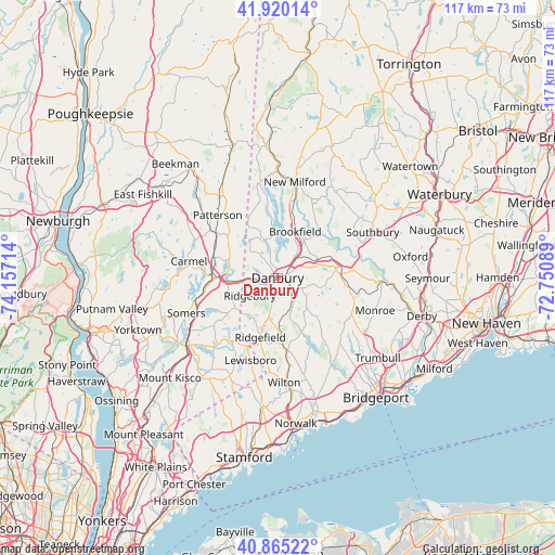
Danbury GPS coordinates[2]
41° 23' 41.352" North, 73° 27' 14.436" West
| Map corner | latitude | longitude |
|---|---|---|
| Upper-left | 41.92014°, | -74.15714° |
| Center: | 41.39482°, | -73.45401° |
| Lower-right: | 40.86522°, | -72.75089° |
| Map W x H: | 117.3×117.3 km | = 72.9×72.9mi |
| max Lat: | 71.29058° ⇑30.3% North |
| Danbury: | 41.39482° |
| min Lat: | ⇓69.7% South 19.06759° |
| min Long | Danbury | max Long |
| -171.73463° | -73.45401° | -66.98998° |
| W 92.9%⇐ | ⇒7.1% E |
Elevation
Elevation of Danbury is 126 m = 413 ft, and this is 168.8 m = 554 ft below average elevation for this country.
| Max E: |
3189 m = 10463 ft | 65.5% |
| Avg. | 294.8 m = 967 ft | |
| Danbury | 126 m = 413 ft | |
Min E: |
-60 m = -197 ft | 34.5% |
See also: Danbury elevation on elevation.city.
Geographical zone
Danbury is located in North temperate zone (between Tropic of Cancer and the Arctic Circle). Distance of this Northern Tropic circle is 1996.8 km =1240.8 mi to South.| Distance of | km | miles | from Danbury |
|---|---|---|---|
| North Pole | 5404.4 | 3358.1 | to North |
| Arctic Circle | 2798.5 | 1738.9 | to North |
| Tropic Cancer | 1996.8 | 1240.8 | to South |
| Equator | 4602.7 | 2860 | to South |


Nearby cities:
15 places around Danbury: (largest is in red/bold)
• Bethel
4.2 km =2.6 mi,  128°
128°
• Brewster
13.6 km =8.5 mi,  271°
271°
• Brewster Hill
12.9 km =8 mi,  284°
284°
• Carmel
19.3 km =12 mi, 281°
• Carmel Hamlet
19.4 km =12.1 mi, 276°
• Easton
20.5 km =12.7 mi,  140°
140°
• Georgetown
15.6 km =9.7 mi,  174°
174°
• Heritage Village
20.7 km =12.9 mi,  60°
60°
• Lake Carmel
19.5 km =12.1 mi,  292°
292°
• New Fairfield
8.4 km =5.2 mi,  341°
341°
• New Milford
20.6 km =12.8 mi,  10°
10°
• Newtown
12.7 km =7.9 mi,  80°
80°
• Peach Lake
10.8 km =6.7 mi,  253°
253°
• Putnam Lake
10.7 km =6.6 mi,  314°
314°
• Ridgefield
13.1 km =8.1 mi,  196°
196°
Sources, notices
• [Note1] Compared only with cities in United States existing in our database
• [Src1] Map data: © OpenStreetMap contributors (CC-BY-SA)
• [Src2] Other city data from geonames.org with taken over terms of usage.
• [Src3] Geographical zone / Annual Mean Temperature by Robert A. Rohde @ Wikipedia
