Georgetown geodata
Georgetown (Connecticut) is a populated place; located in United States in America/New_York (GMT-4) time zone. With population of 1,805 people, there are 12522 cities with bigger population in this country. Compared to other cities in United States, 68.4% of cities are located further ↓South; 93% of cities are located further ←West and 68% of cities have higher elevation than Georgetown. Note1


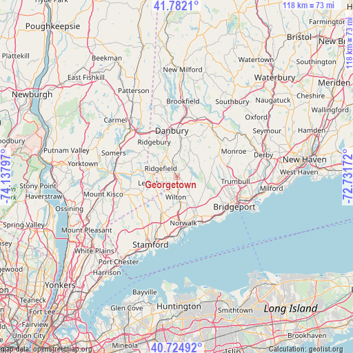
Georgetown GPS coordinates[2]
41° 15' 20.34" North, 73° 26' 5.424" West
| Map corner | latitude | longitude |
|---|---|---|
| Upper-left | 41.7821°, | -74.13797° |
| Center: | 41.25565°, | -73.43484° |
| Lower-right: | 40.72492°, | -72.73172° |
| Map W x H: | 117.5×117.5 km | = 73×73mi |
| max Lat: | 71.29058° ⇑31.6% North |
| Georgetown: | 41.25565° |
| min Lat: | ⇓68.4% South 19.06759° |
| min Long | Georgetown | max Long |
| -171.73463° | -73.43484° | -66.98998° |
| W 93%⇐ | ⇒7% E |
Elevation
Elevation of Georgetown is 112 m = 367 ft, and this is 182.8 m = 600 ft below average elevation for this country.
| Max E: |
3189 m = 10463 ft | 68% |
| Avg. | 294.8 m = 967 ft | |
| Georgetown | 112 m = 367 ft | |
Min E: |
-60 m = -197 ft | 32% |
See also: United States elevation on elevation.city.
Geographical zone
Georgetown is located in North temperate zone (between Tropic of Cancer and the Arctic Circle). Distance of this Northern Tropic circle is 1981.3 km =1231.1 mi to South.| Distance of | km | miles | from Georgetown |
|---|---|---|---|
| North Pole | 5419.9 | 3367.8 | to North |
| Arctic Circle | 2814 | 1748.5 | to North |
| Tropic Cancer | 1981.3 | 1231.1 | to South |
| Equator | 4587.2 | 2850.4 | to South |


Nearby cities:
15 places around Georgetown: (largest is in red/bold)
• Bedford
18.4 km =11.4 mi,  251°
251°
• Bethel
13 km =8.1 mi,  7°
7°
• Danbury
15.6 km =9.7 mi,  354°
354°
• East Norwalk
17 km =10.6 mi,  169°
169°
• Easton
11.5 km =7.1 mi,  91°
91°
• New Canaan
13.1 km =8.1 mi,  202°
202°
• North Stamford
15.9 km =9.9 mi,  214°
214°
• Norwalk
15.5 km =9.6 mi, 171°
• Peach Lake
17.3 km =10.7 mi,  316°
316°
• Pound Ridge
12.8 km =8 mi, 245°
• Ridgefield
6 km =3.7 mi,  298°
298°
• Scotts Corners
12.2 km =7.6 mi,  232°
232°
• Southport
18.3 km =11.4 mi,  136°
136°
• Westport
14.2 km =8.8 mi,  153°
153°
• Wilton
6.7 km =4.2 mi,  182°
182°
Sources, notices
• [Note1] Compared only with cities in United States existing in our database
• [Src1] Map data: © OpenStreetMap contributors (CC-BY-SA)
• [Src2] Other city data from geonames.org with taken over terms of usage.
• [Src3] Geographical zone / Annual Mean Temperature by Robert A. Rohde @ Wikipedia
