Edina geodata
Edina (Missouri) is a seat of a second-order administrative division; located in United States in America/Chicago (GMT-5) time zone. With population of 1,108 people, there are 15629 cities with bigger population in this country. Compared to other cities in United States, 55.2% of cities are located further ↓South; 64.5% of cities are located further →East and 62.1% of cities have lower elevation than Edina. Note1


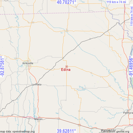
Edina GPS coordinates[2]
40° 10' 3.144" North, 92° 10' 21.648" West
| Map corner | latitude | longitude |
|---|---|---|
| Upper-left | 40.70271°, | -92.87581° |
| Center: | 40.16754°, | -92.17268° |
| Lower-right: | 39.62811°, | -91.46956° |
| Map W x H: | 119.5×119.5 km | = 74.3×74.3mi |
| max Lat: | 71.29058° ⇑44.8% North |
| Edina: | 40.16754° |
| min Lat: | ⇓55.2% South 19.06759° |
| min Long | Edina | max Long |
| -171.73463° | -92.17268° | -66.98998° |
| W 35.5%⇐ | ⇒64.5% E |
Elevation
Elevation of Edina is 249 m = 817 ft, and this is 45.8 m = 150 ft below average elevation for this country.
| Max E: |
3189 m = 10463 ft | 37.9% |
| Avg. | 294.8 m = 967 ft | |
| Edina | 249 m = 817 ft | |
Min E: |
-60 m = -197 ft | 62.1% |
See also: United States elevation on elevation.city.
Geographical zone
Edina is located in North temperate zone (between Tropic of Cancer and the Arctic Circle). Distance of this Northern Tropic circle is 1860.3 km =1155.9 mi to South.| Distance of | km | miles | from Edina |
|---|---|---|---|
| North Pole | 5540.9 | 3443 | to North |
| Arctic Circle | 2935 | 1823.7 | to North |
| Tropic Cancer | 1860.3 | 1155.9 | to South |
| Equator | 4466.2 | 2775.2 | to South |


Nearby cities:
15 places around Edina: (largest is in red/bold)
• Canton
46.8 km =29.1 mi,  95°
95°
• Clarence
47.9 km =29.8 mi,  188°
188°
• Kahoka
47.6 km =29.6 mi,  53°
53°
• Kirksville
35 km =21.7 mi,  274°
274°
• La Belle
22.8 km =14.2 mi, 104°
• La Plata
31.5 km =19.6 mi,  239°
239°
• Lancaster
49.5 km =30.8 mi,  322°
322°
• Lewistown
31.9 km =19.8 mi,  106°
106°
• Macon
53.8 km =33.4 mi,  208°
208°
• Memphis
32.3 km =20.1 mi,  0°
0°
• Monticello
39.5 km =24.5 mi, 97°
• Queen City
42.9 km =26.7 mi,  308°
308°
• Shelbina
53.8 km =33.4 mi,  168°
168°
• Shelbyville
41.7 km =25.9 mi,  164°
164°
• Wayland
56 km =34.8 mi,  63°
63°
Sources, notices
• [Note1] Compared only with cities in United States existing in our database
• [Src1] Map data: © OpenStreetMap contributors (CC-BY-SA)
• [Src2] Other city data from geonames.org with taken over terms of usage.
• [Src3] Geographical zone / Annual Mean Temperature by Robert A. Rohde @ Wikipedia
