Lewistown geodata
Lewistown (Missouri) is a populated place; located in United States in America/Chicago (GMT-5) time zone. With population of 529 people, there are 20514 cities with bigger population in this country. Compared to other cities in United States, 54.4% of cities are located further ↓South; 63.7% of cities are located further →East and 56.1% of cities have lower elevation than Lewistown. Note1


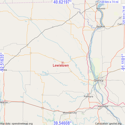
Lewistown GPS coordinates[2]
40° 5' 10.14" North, 91° 48' 47.592" West
| Map corner | latitude | longitude |
|---|---|---|
| Upper-left | 40.62197°, | -92.51635° |
| Center: | 40.08615°, | -91.81322° |
| Lower-right: | 39.54608°, | -91.1101° |
| Map W x H: | 119.6×119.6 km | = 74.3×74.3mi |
| max Lat: | 71.29058° ⇑45.6% North |
| Lewistown: | 40.08615° |
| min Lat: | ⇓54.4% South 19.06759° |
| min Long | Lewistown | max Long |
| -171.73463° | -91.81322° | -66.98998° |
| W 36.3%⇐ | ⇒63.7% E |
Elevation
Elevation of Lewistown is 223 m = 732 ft, and this is 71.8 m = 236 ft below average elevation for this country.
| Max E: |
3189 m = 10463 ft | 43.9% |
| Avg. | 294.8 m = 967 ft | |
| Lewistown | 223 m = 732 ft | |
Min E: |
-60 m = -197 ft | 56.1% |
See also: United States elevation on elevation.city.
Geographical zone
Lewistown is located in North temperate zone (between Tropic of Cancer and the Arctic Circle). Distance of this Northern Tropic circle is 1851.2 km =1150.3 mi to South.| Distance of | km | miles | from Lewistown |
|---|---|---|---|
| North Pole | 5549.9 | 3448.5 | to North |
| Arctic Circle | 2944 | 1829.3 | to North |
| Tropic Cancer | 1851.2 | 1150.3 | to South |
| Equator | 4457.2 | 2769.6 | to South |


Nearby cities:
15 places around Lewistown: (largest is in red/bold)
• Canton
16.6 km =10.3 mi,  74°
74°
• Edina
31.9 km =19.8 mi,  286°
286°
• Kahoka
38 km =23.6 mi,  12°
12°
• La Belle
9.1 km =5.7 mi, 292°
• La Grange
27.3 km =17 mi,  100°
100°
• Mendon
45 km =28 mi,  89°
89°
• Monroe City
48.6 km =30.2 mi,  172°
172°
• Monticello
9.3 km =5.8 mi, 67°
• Palmyra
40.8 km =25.4 mi,  142°
142°
• Quincy
38.2 km =23.7 mi,  115°
115°
• Shelbina
47.8 km =29.7 mi,  204°
204°
• Shelbyville
36.7 km =22.8 mi,  211°
211°
• Ursa
38 km =23.6 mi, 91°
• Warsaw
44.2 km =27.5 mi,  46°
46°
• Wayland
39.5 km =24.5 mi,  29°
29°
Sources, notices
• [Note1] Compared only with cities in United States existing in our database
• [Src1] Map data: © OpenStreetMap contributors (CC-BY-SA)
• [Src2] Other city data from geonames.org with taken over terms of usage.
• [Src3] Geographical zone / Annual Mean Temperature by Robert A. Rohde @ Wikipedia
