Monticello geodata
Monticello (Missouri) is a seat of a second-order administrative division; located in United States in America/Chicago (GMT-5) time zone. With population of 99 people, there are 21039 cities with bigger population in this country. Compared to other cities in United States, 54.8% of cities are located further ↓South; 63.5% of cities are located further →East and 50.8% of cities have higher elevation than Monticello. Note1


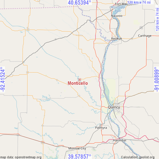
Monticello GPS coordinates[2]
40° 7' 6.168" North, 91° 42' 43.596" West
| Map corner | latitude | longitude |
|---|---|---|
| Upper-left | 40.65394°, | -92.41524° |
| Center: | 40.11838°, | -91.71211° |
| Lower-right: | 39.57857°, | -91.00899° |
| Map W x H: | 119.6×119.6 km | = 74.3×74.3mi |
| max Lat: | 71.29058° ⇑45.2% North |
| Monticello: | 40.11838° |
| min Lat: | ⇓54.8% South 19.06759° |
| min Long | Monticello | max Long |
| -171.73463° | -91.71211° | -66.98998° |
| W 36.5%⇐ | ⇒63.5% E |
Elevation
Elevation of Monticello is 195 m = 640 ft, and this is 99.8 m = 327 ft below average elevation for this country.
| Max E: |
3189 m = 10463 ft | 50.8% |
| Avg. | 294.8 m = 967 ft | |
| Monticello | 195 m = 640 ft | |
Min E: |
-60 m = -197 ft | 49.2% |
See also: United States elevation on elevation.city.
Geographical zone
Monticello is located in North temperate zone (between Tropic of Cancer and the Arctic Circle). Distance of this Northern Tropic circle is 1854.8 km =1152.5 mi to South.| Distance of | km | miles | from Monticello |
|---|---|---|---|
| North Pole | 5546.3 | 3446.3 | to North |
| Arctic Circle | 2940.4 | 1827.1 | to North |
| Tropic Cancer | 1854.8 | 1152.5 | to South |
| Equator | 4460.7 | 2771.7 | to South |


Nearby cities:
15 places around Monticello: (largest is in red/bold)
• Canton
7.4 km =4.6 mi,  84°
84°
• Edina
39.5 km =24.5 mi,  277°
277°
• Hamilton
44.2 km =27.5 mi,  45°
45°
• Kahoka
33.6 km =20.9 mi,  358°
358°
• Keokuk
41.6 km =25.8 mi,  41°
41°
• La Belle
17.1 km =10.6 mi,  269°
269°
• La Grange
20.1 km =12.5 mi,  114°
114°
• Lewistown
9.3 km =5.8 mi,  247°
247°
• Mendon
36.6 km =22.7 mi,  95°
95°
• Palmyra
39.5 km =24.5 mi,  155°
155°
• Quincy
32.8 km =20.4 mi,  128°
128°
• Shelbyville
44.7 km =27.8 mi,  218°
218°
• Ursa
29.7 km =18.5 mi, 99°
• Warsaw
35.7 km =22.2 mi, 41°
• Wayland
32.6 km =20.3 mi,  19°
19°
Sources, notices
• [Note1] Compared only with cities in United States existing in our database
• [Src1] Map data: © OpenStreetMap contributors (CC-BY-SA)
• [Src2] Other city data from geonames.org with taken over terms of usage.
• [Src3] Geographical zone / Annual Mean Temperature by Robert A. Rohde @ Wikipedia
