La Belle geodata
La Belle (Missouri) is a populated place; located in United States in America/Chicago (GMT-5) time zone. With population of 657 people, there are 19109 cities with bigger population in this country. Compared to other cities in United States, 54.7% of cities are located further ↓South; 63.9% of cities are located further →East and 57.2% of cities have lower elevation than La Belle. Note1


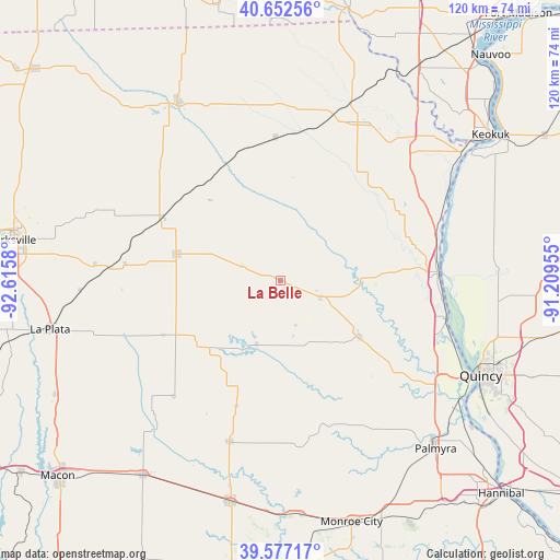
La Belle GPS coordinates[2]
40° 7' 1.164" North, 91° 54' 45.612" West
| Map corner | latitude | longitude |
|---|---|---|
| Upper-left | 40.65256°, | -92.6158° |
| Center: | 40.11699°, | -91.91267° |
| Lower-right: | 39.57717°, | -91.20955° |
| Map W x H: | 119.6×119.6 km | = 74.3×74.3mi |
| max Lat: | 71.29058° ⇑45.3% North |
| La Belle: | 40.11699° |
| min Lat: | ⇓54.7% South 19.06759° |
| min Long | La Belle | max Long |
| -171.73463° | -91.91267° | -66.98998° |
| W 36.1%⇐ | ⇒63.9% E |
Elevation
Elevation of La Belle is 227 m = 745 ft, and this is 67.8 m = 222 ft below average elevation for this country.
| Max E: |
3189 m = 10463 ft | 42.8% |
| Avg. | 294.8 m = 967 ft | |
| La Belle | 227 m = 745 ft | |
Min E: |
-60 m = -197 ft | 57.2% |
See also: United States elevation on elevation.city.
Geographical zone
La Belle is located in North temperate zone (between Tropic of Cancer and the Arctic Circle). Distance of this Northern Tropic circle is 1854.7 km =1152.5 mi to South.| Distance of | km | miles | from La Belle |
|---|---|---|---|
| North Pole | 5546.5 | 3446.4 | to North |
| Arctic Circle | 2940.6 | 1827.2 | to North |
| Tropic Cancer | 1854.7 | 1152.5 | to South |
| Equator | 4460.6 | 2771.7 | to South |


Nearby cities:
15 places around La Belle: (largest is in red/bold)
• Canton
24.5 km =15.2 mi,  87°
87°
• Edina
22.8 km =14.2 mi,  284°
284°
• Kahoka
37.5 km =23.3 mi,  25°
25°
• La Grange
36.3 km =22.6 mi,  103°
103°
• La Plata
50.3 km =31.3 mi,  258°
258°
• Lewistown
9.1 km =5.7 mi,  112°
112°
• Memphis
43.8 km =27.2 mi,  329°
329°
• Monticello
17.1 km =10.6 mi, 89°
• Palmyra
48.9 km =30.4 mi,  137°
137°
• Quincy
47.3 km =29.4 mi,  115°
115°
• Shelbina
48.3 km =30 mi,  193°
193°
• Shelbyville
36.3 km =22.6 mi,  197°
197°
• Ursa
46.6 km =29 mi, 95°
• Warsaw
48.7 km =30.3 mi,  56°
56°
• Wayland
41.6 km =25.8 mi,  42°
42°
Sources, notices
• [Note1] Compared only with cities in United States existing in our database
• [Src1] Map data: © OpenStreetMap contributors (CC-BY-SA)
• [Src2] Other city data from geonames.org with taken over terms of usage.
• [Src3] Geographical zone / Annual Mean Temperature by Robert A. Rohde @ Wikipedia
