Westport geodata
Westport (Connecticut) is a populated place; located in United States in America/New_York (GMT-4) time zone. With population of 26,391 people, there are 1901 cities with bigger population in this country. Compared to other cities in United States, 67.3% of cities are located further ↓South; 93.1% of cities are located further ←West and 91.5% of cities have higher elevation than Westport. Note1
Administrative division(s):
- Level 1: Connecticut
- Level 2: Fairfield County
- Level 3: Town of Westport


Westport GPS coordinates[2]
41° 8' 29.364" North, 73° 21' 28.44" West
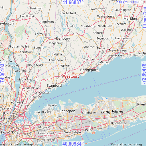
| Map corner | latitude | longitude |
|---|---|---|
| Upper-left | 41.66887°, | -74.06103° |
| Center: | 41.14149°, | -73.3579° |
| Lower-right: | 40.60984°, | -72.65478° |
| Map W x H: | 117.8×117.8 km | = 73.2×73.2mi |
| max Lat: | 71.29058° ⇑32.7% North |
| Westport: | 41.14149° |
| min Lat: | ⇓67.3% South 19.06759° |
| min Long | Westport | max Long |
| -171.73463° | -73.3579° | -66.98998° |
| W 93.1%⇐ | ⇒6.9% E |
Elevation
Elevation of Westport is 13 m = 43 ft, and this is 281.8 m = 925 ft below average elevation for this country.
| Max E: |
3189 m = 10463 ft | 91.5% |
| Avg. | 294.8 m = 967 ft | |
| Westport | 13 m = 43 ft | |
Min E: |
-60 m = -197 ft | 8.5% |
See also: United States elevation on elevation.city.
Geographical zone
Westport is located in North temperate zone (between Tropic of Cancer and the Arctic Circle). Distance of this Northern Tropic circle is 1968.6 km =1223.2 mi to South.| Distance of | km | miles | from Westport |
|---|---|---|---|
| North Pole | 5432.6 | 3375.7 | to North |
| Arctic Circle | 2826.7 | 1756.4 | to North |
| Tropic Cancer | 1968.6 | 1223.2 | to South |
| Equator | 4574.5 | 2842.5 | to South |


Nearby cities:
15 places around Westport: (largest is in red/bold)
• Bridgeport
14.7 km =9.1 mi,  73°
73°
• Darien
11.7 km =7.3 mi,  233°
233°
• East Norwalk
5.2 km =3.2 mi,  220°
220°
• Easton
13.4 km =8.3 mi,  22°
22°
• Fairfield
7.9 km =4.9 mi,  90°
90°
• Georgetown
14.2 km =8.8 mi,  333°
333°
• New Canaan
11.5 km =7.1 mi,  272°
272°
• North Stamford
15.5 km =9.6 mi, 268°
• Norwalk
5 km =3.1 mi,  237°
237°
• Scotts Corners
17 km =10.6 mi,  288°
288°
• Southport
6.3 km =3.9 mi,  95°
95°
• Stamford
18 km =11.2 mi, 237°
• Stratford
19.4 km =12.1 mi,  75°
75°
• Trumbull
17.3 km =10.7 mi,  49°
49°
• Wilton
9 km =5.6 mi,  311°
311°
Sources, notices
• [Note1] Compared only with cities in United States existing in our database
• [Src1] Map data: © OpenStreetMap contributors (CC-BY-SA)
• [Src2] Other city data from geonames.org with taken over terms of usage.
• [Src3] Geographical zone / Annual Mean Temperature by Robert A. Rohde @ Wikipedia
