Kirkwood geodata
Kirkwood (Illinois) is a populated place; located in United States in America/Chicago (GMT-5) time zone. With population of 704 people, there are 18635 cities with bigger population in this country. Compared to other cities in United States, 64.2% of cities are located further ↓South; 61.6% of cities are located further →East and 58.4% of cities have lower elevation than Kirkwood. Note1


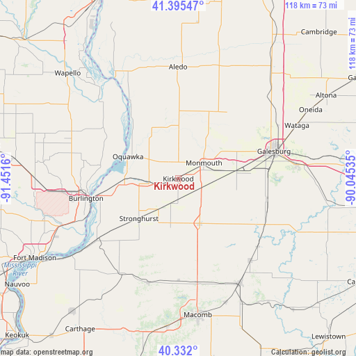
Kirkwood GPS coordinates[2]
40° 51' 57.132" North, 90° 44' 54.492" West
| Map corner | latitude | longitude |
|---|---|---|
| Upper-left | 41.39547°, | -91.4516° |
| Center: | 40.86587°, | -90.74847° |
| Lower-right: | 40.332°, | -90.04535° |
| Map W x H: | 118.2×118.2 km | = 73.4×73.4mi |
| max Lat: | 71.29058° ⇑35.8% North |
| Kirkwood: | 40.86587° |
| min Lat: | ⇓64.2% South 19.06759° |
| min Long | Kirkwood | max Long |
| -171.73463° | -90.74847° | -66.98998° |
| W 38.4%⇐ | ⇒61.6% E |
Elevation
Elevation of Kirkwood is 232 m = 761 ft, and this is 62.8 m = 206 ft below average elevation for this country.
| Max E: |
3189 m = 10463 ft | 41.6% |
| Avg. | 294.8 m = 967 ft | |
| Kirkwood | 232 m = 761 ft | |
Min E: |
-60 m = -197 ft | 58.4% |
See also: United States elevation on elevation.city.
Geographical zone
Kirkwood is located in North temperate zone (between Tropic of Cancer and the Arctic Circle). Distance of this Northern Tropic circle is 1937.9 km =1204.2 mi to South.| Distance of | km | miles | from Kirkwood |
|---|---|---|---|
| North Pole | 5463.2 | 3394.7 | to North |
| Arctic Circle | 2857.3 | 1775.4 | to North |
| Tropic Cancer | 1937.9 | 1204.2 | to South |
| Equator | 4543.9 | 2823.4 | to South |


Nearby cities:
15 places around Kirkwood: (largest is in red/bold)
• Abingdon
30 km =18.6 mi,  103°
103°
• Aledo
37.1 km =23.1 mi,  359°
359°
• Alexis
27.3 km =17 mi,  36°
36°
• Avon
34.6 km =21.5 mi,  130°
130°
• Blandinsville
35.8 km =22.2 mi,  196°
196°
• Burlington
31.3 km =19.4 mi,  258°
258°
• East Galesburg
37.9 km =23.5 mi,  76°
76°
• Galesburg
33 km =20.5 mi,  73°
73°
• Keithsburg
30.7 km =19.1 mi,  327°
327°
• La Harpe
36.5 km =22.7 mi,  210°
210°
• Monmouth
9.9 km =6.2 mi,  59°
59°
• Oquawka
18.2 km =11.3 mi,  293°
293°
• Roseville
16.4 km =10.2 mi,  154°
154°
• Stronghurst
18.6 km =11.6 mi,  224°
224°
• West Burlington
34.6 km =21.5 mi, 262°
Sources, notices
• [Note1] Compared only with cities in United States existing in our database
• [Src1] Map data: © OpenStreetMap contributors (CC-BY-SA)
• [Src2] Other city data from geonames.org with taken over terms of usage.
• [Src3] Geographical zone / Annual Mean Temperature by Robert A. Rohde @ Wikipedia
