Wataga geodata
Wataga (Illinois) is a populated place; located in United States in America/Chicago (GMT-5) time zone. With population of 816 people, there are 17663 cities with bigger population in this country. Compared to other cities in United States, 66.2% of cities are located further ↓South; 59.9% of cities are located further →East and 63.3% of cities have lower elevation than Wataga. Note1


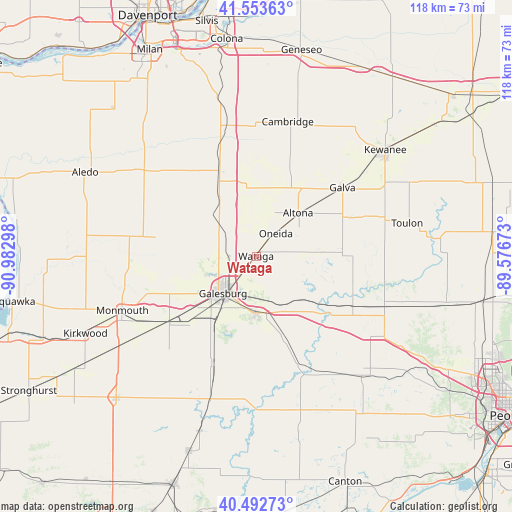
Wataga GPS coordinates[2]
41° 1' 31.152" North, 90° 16' 47.46" West
| Map corner | latitude | longitude |
|---|---|---|
| Upper-left | 41.55363°, | -90.98298° |
| Center: | 41.02532°, | -90.27985° |
| Lower-right: | 40.49273°, | -89.57673° |
| Map W x H: | 118×118 km | = 73.3×73.3mi |
| max Lat: | 71.29058° ⇑33.8% North |
| Wataga: | 41.02532° |
| min Lat: | ⇓66.2% South 19.06759° |
| min Long | Wataga | max Long |
| -171.73463° | -90.27985° | -66.98998° |
| W 40.1%⇐ | ⇒59.9% E |
Elevation
Elevation of Wataga is 254 m = 833 ft, and this is 40.8 m = 134 ft below average elevation for this country.
| Max E: |
3189 m = 10463 ft | 36.7% |
| Avg. | 294.8 m = 967 ft | |
| Wataga | 254 m = 833 ft | |
Min E: |
-60 m = -197 ft | 63.3% |
See also: United States elevation on elevation.city.
Geographical zone
Wataga is located in North temperate zone (between Tropic of Cancer and the Arctic Circle). Distance of this Northern Tropic circle is 1955.7 km =1215.2 mi to South.| Distance of | km | miles | from Wataga |
|---|---|---|---|
| North Pole | 5445.5 | 3383.7 | to North |
| Arctic Circle | 2839.6 | 1764.4 | to North |
| Tropic Cancer | 1955.7 | 1215.2 | to South |
| Equator | 4561.6 | 2834.4 | to South |


Nearby cities:
15 places around Wataga: (largest is in red/bold)
• Abingdon
26.6 km =16.5 mi,  202°
202°
• Alexis
23.5 km =14.6 mi,  280°
280°
• Alpha
20.3 km =12.6 mi,  335°
335°
• Altona
13.9 km =8.6 mi,  44°
44°
• Andover
29.9 km =18.6 mi,  358°
358°
• Cambridge
31.8 km =19.8 mi,  13°
13°
• East Galesburg
9 km =5.6 mi, 196°
• Galesburg
11.5 km =7.1 mi,  221°
221°
• Galva
25.4 km =15.8 mi,  51°
51°
• Knoxville
13 km =8.1 mi,  181°
181°
• New Windsor
23.9 km =14.9 mi,  325°
325°
• Oak Run
13.2 km =8.2 mi,  121°
121°
• Oneida
6.9 km =4.3 mi, 41°
• Williamsfield
25 km =15.5 mi, 117°
• Woodhull
17.3 km =10.7 mi,  349°
349°
Sources, notices
• [Note1] Compared only with cities in United States existing in our database
• [Src1] Map data: © OpenStreetMap contributors (CC-BY-SA)
• [Src2] Other city data from geonames.org with taken over terms of usage.
• [Src3] Geographical zone / Annual Mean Temperature by Robert A. Rohde @ Wikipedia
