Monmouth geodata
Monmouth (Illinois) is a seat of a second-order administrative division; located in United States in America/Chicago (GMT-5) time zone. With population of 9,291 people, there are 4692 cities with bigger population in this country. Compared to other cities in United States, 64.9% of cities are located further ↓South; 61.3% of cities are located further →East and 59.1% of cities have lower elevation than Monmouth. Note1


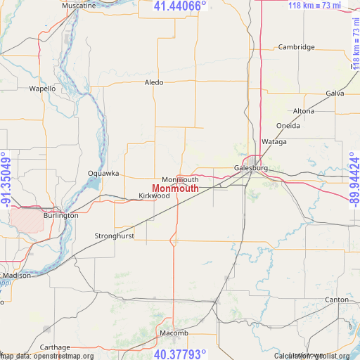
Monmouth GPS coordinates[2]
40° 54' 41.148" North, 90° 38' 50.496" West
| Map corner | latitude | longitude |
|---|---|---|
| Upper-left | 41.44066°, | -91.35049° |
| Center: | 40.91143°, | -90.64736° |
| Lower-right: | 40.37793°, | -89.94424° |
| Map W x H: | 118.2×118.2 km | = 73.4×73.4mi |
| max Lat: | 71.29058° ⇑35.1% North |
| Monmouth: | 40.91143° |
| min Lat: | ⇓64.9% South 19.06759° |
| min Long | Monmouth | max Long |
| -171.73463° | -90.64736° | -66.98998° |
| W 38.7%⇐ | ⇒61.3% E |
Elevation
Elevation of Monmouth is 236 m = 774 ft, and this is 58.8 m = 193 ft below average elevation for this country.
| Max E: |
3189 m = 10463 ft | 40.9% |
| Avg. | 294.8 m = 967 ft | |
| Monmouth | 236 m = 774 ft | |
Min E: |
-60 m = -197 ft | 59.1% |
See also: United States elevation on elevation.city.
Geographical zone
Monmouth is located in North temperate zone (between Tropic of Cancer and the Arctic Circle). Distance of this Northern Tropic circle is 1943 km =1207.3 mi to South.| Distance of | km | miles | from Monmouth |
|---|---|---|---|
| North Pole | 5458.1 | 3391.5 | to North |
| Arctic Circle | 2852.2 | 1772.3 | to North |
| Tropic Cancer | 1943 | 1207.3 | to South |
| Equator | 4548.9 | 2826.6 | to South |


Nearby cities:
15 places around Monmouth: (largest is in red/bold)
• Abingdon
23.8 km =14.8 mi,  119°
119°
• Aledo
33.2 km =20.6 mi,  345°
345°
• Alexis
18.6 km =11.6 mi,  24°
24°
• Avon
32.8 km =20.4 mi,  146°
146°
• East Galesburg
28.6 km =17.8 mi,  81°
81°
• Galesburg
23.5 km =14.6 mi, 80°
• Keithsburg
32.4 km =20.1 mi,  310°
310°
• Kirkwood
9.9 km =6.2 mi,  239°
239°
• Knoxville
30.5 km =19 mi,  90°
90°
• New Windsor
36.6 km =22.7 mi,  27°
27°
• Oquawka
25.3 km =15.7 mi,  275°
275°
• Roseville
20 km =12.4 mi,  184°
184°
• Stronghurst
28.3 km =17.6 mi,  229°
229°
• Viola
32.8 km =20.4 mi,  8°
8°
• Wataga
33.4 km =20.8 mi,  67°
67°
Sources, notices
• [Note1] Compared only with cities in United States existing in our database
• [Src1] Map data: © OpenStreetMap contributors (CC-BY-SA)
• [Src2] Other city data from geonames.org with taken over terms of usage.
• [Src3] Geographical zone / Annual Mean Temperature by Robert A. Rohde @ Wikipedia
