Gridley geodata
Gridley (Illinois) is a populated place; located in United States in America/Chicago (GMT-5) time zone. With population of 1,439 people, there are 13926 cities with bigger population in this country. Compared to other cities in United States, 62.2% of cities are located further ↓South; 55.8% of cities are located further →East and 58.4% of cities have lower elevation than Gridley. Note1


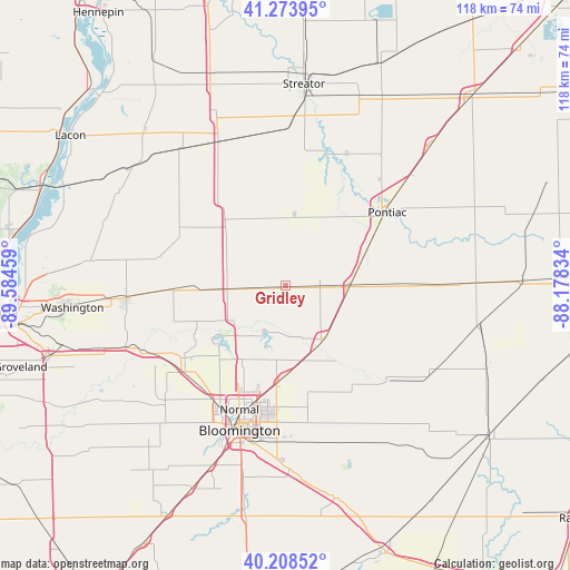
Gridley GPS coordinates[2]
40° 44' 36.132" North, 88° 52' 53.256" West
| Map corner | latitude | longitude |
|---|---|---|
| Upper-left | 41.27395°, | -89.58459° |
| Center: | 40.74337°, | -88.88146° |
| Lower-right: | 40.20852°, | -88.17834° |
| Map W x H: | 118.5×118.5 km | = 73.6×73.6mi |
| max Lat: | 71.29058° ⇑37.8% North |
| Gridley: | 40.74337° |
| min Lat: | ⇓62.2% South 19.06759° |
| min Long | Gridley | max Long |
| -171.73463° | -88.88146° | -66.98998° |
| W 44.2%⇐ | ⇒55.8% E |
Elevation
Elevation of Gridley is 232 m = 761 ft, and this is 62.8 m = 206 ft below average elevation for this country.
| Max E: |
3189 m = 10463 ft | 41.6% |
| Avg. | 294.8 m = 967 ft | |
| Gridley | 232 m = 761 ft | |
Min E: |
-60 m = -197 ft | 58.4% |
See also: United States elevation on elevation.city.
Geographical zone
Gridley is located in North temperate zone (between Tropic of Cancer and the Arctic Circle). Distance of this Northern Tropic circle is 1924.3 km =1195.7 mi to South.| Distance of | km | miles | from Gridley |
|---|---|---|---|
| North Pole | 5476.8 | 3403.1 | to North |
| Arctic Circle | 2870.9 | 1783.9 | to North |
| Tropic Cancer | 1924.3 | 1195.7 | to South |
| Equator | 4530.2 | 2814.9 | to South |


Nearby cities:
15 places around Gridley: (largest is in red/bold)
• Bloomington
30.3 km =18.8 mi,  198°
198°
• Carlock
27.7 km =17.2 mi,  229°
229°
• Chenoa
13.6 km =8.5 mi,  90°
90°
• Colfax
29.7 km =18.5 mi,  131°
131°
• El Paso
11.4 km =7.1 mi,  267°
267°
• Fairbury
30.9 km =19.2 mi, 89°
• Flanagan
15.1 km =9.4 mi,  6°
6°
• Hudson
17.7 km =11 mi,  210°
210°
• Lexington
14 km =8.7 mi,  143°
143°
• Minonk
22.1 km =13.7 mi,  324°
324°
• Normal
27.1 km =16.8 mi, 199°
• Pleasant Hill
18.4 km =11.4 mi, 141°
• Pontiac
26.1 km =16.2 mi,  54°
54°
• Roanoke
27.2 km =16.9 mi,  282°
282°
• Twin Grove
32.4 km =20.1 mi, 211°
Sources, notices
• [Note1] Compared only with cities in United States existing in our database
• [Src1] Map data: © OpenStreetMap contributors (CC-BY-SA)
• [Src2] Other city data from geonames.org with taken over terms of usage.
• [Src3] Geographical zone / Annual Mean Temperature by Robert A. Rohde @ Wikipedia
