Ossian geodata
Ossian (Indiana) is a populated place; located in United States in America/Indiana/Indianapolis (GMT-4) time zone. With population of 3,341 people, there are 9077 cities with bigger population in this country. Compared to other cities in United States, 64.4% of cities are located further ↓South; 55.5% of cities are located further ←West and 63.9% of cities have lower elevation than Ossian. Note1


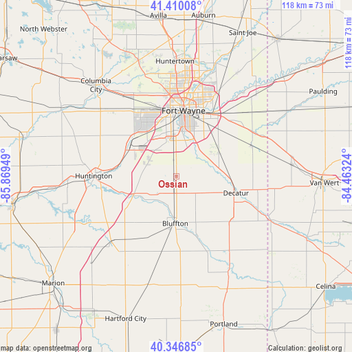
Ossian GPS coordinates[2]
40° 52' 50.16" North, 85° 9' 58.896" West
| Map corner | latitude | longitude |
|---|---|---|
| Upper-left | 41.41008°, | -85.86949° |
| Center: | 40.8806°, | -85.16636° |
| Lower-right: | 40.34685°, | -84.46324° |
| Map W x H: | 118.2×118.2 km | = 73.4×73.4mi |
| max Lat: | 71.29058° ⇑35.6% North |
| Ossian: | 40.8806° |
| min Lat: | ⇓64.4% South 19.06759° |
| min Long | Ossian | max Long |
| -171.73463° | -85.16636° | -66.98998° |
| W 55.5%⇐ | ⇒44.5% E |
Elevation
Elevation of Ossian is 257 m = 843 ft, and this is 37.8 m = 124 ft below average elevation for this country.
| Max E: |
3189 m = 10463 ft | 36.1% |
| Avg. | 294.8 m = 967 ft | |
| Ossian | 257 m = 843 ft | |
Min E: |
-60 m = -197 ft | 63.9% |
See also: United States elevation on elevation.city.
Geographical zone
Ossian is located in North temperate zone (between Tropic of Cancer and the Arctic Circle). Distance of this Northern Tropic circle is 1939.6 km =1205.2 mi to South.| Distance of | km | miles | from Ossian |
|---|---|---|---|
| North Pole | 5461.6 | 3393.7 | to North |
| Arctic Circle | 2855.7 | 1774.4 | to North |
| Tropic Cancer | 1939.6 | 1205.2 | to South |
| Equator | 4545.5 | 2824.4 | to South |


Nearby cities:
15 places around Ossian: (largest is in red/bold)
• Andrews
36.7 km =22.8 mi,  266°
266°
• Berne
30.7 km =19.1 mi,  143°
143°
• Bluffton
15.8 km =9.8 mi,  181°
181°
• Decatur
20.7 km =12.9 mi,  105°
105°
• Fort Wayne
28 km =17.4 mi,  6°
6°
• Geneva
36.6 km =22.7 mi,  151°
151°
• Hoagland
16.5 km =10.3 mi,  63°
63°
• Huntington
27.8 km =17.3 mi, 270°
• Markle
15.8 km =9.8 mi,  246°
246°
• Monroe
24.5 km =15.2 mi,  127°
127°
• Monroeville
27.1 km =16.8 mi,  67°
67°
• New Haven
24.7 km =15.3 mi,  31°
31°
• Roanoke
19.6 km =12.2 mi,  297°
297°
• Warren
31.1 km =19.3 mi,  224°
224°
• Zanesville
10.4 km =6.5 mi,  293°
293°
Sources, notices
• [Note1] Compared only with cities in United States existing in our database
• [Src1] Map data: © OpenStreetMap contributors (CC-BY-SA)
• [Src2] Other city data from geonames.org with taken over terms of usage.
• [Src3] Geographical zone / Annual Mean Temperature by Robert A. Rohde @ Wikipedia
