Zanesville geodata
Zanesville (Indiana) is a populated place; located in United States in America/Indiana/Indianapolis (GMT-4) time zone. With population of 610 people, there are 19583 cities with bigger population in this country. Compared to other cities in United States, 64.9% of cities are located further ↓South; 55.2% of cities are located further ←West and 61.9% of cities have lower elevation than Zanesville. Note1


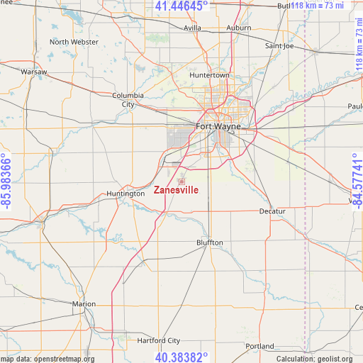
Zanesville GPS coordinates[2]
40° 55' 2.172" North, 85° 16' 49.908" West
| Map corner | latitude | longitude |
|---|---|---|
| Upper-left | 41.44645°, | -85.98366° |
| Center: | 40.91727°, | -85.28053° |
| Lower-right: | 40.38382°, | -84.57741° |
| Map W x H: | 118.2×118.2 km | = 73.4×73.4mi |
| max Lat: | 71.29058° ⇑35.1% North |
| Zanesville: | 40.91727° |
| min Lat: | ⇓64.9% South 19.06759° |
| min Long | Zanesville | max Long |
| -171.73463° | -85.28053° | -66.98998° |
| W 55.2%⇐ | ⇒44.8% E |
Elevation
Elevation of Zanesville is 248 m = 814 ft, and this is 46.8 m = 154 ft below average elevation for this country.
| Max E: |
3189 m = 10463 ft | 38.1% |
| Avg. | 294.8 m = 967 ft | |
| Zanesville | 248 m = 814 ft | |
Min E: |
-60 m = -197 ft | 61.9% |
See also: United States elevation on elevation.city.
Geographical zone
Zanesville is located in North temperate zone (between Tropic of Cancer and the Arctic Circle). Distance of this Northern Tropic circle is 1943.7 km =1207.8 mi to South.| Distance of | km | miles | from Zanesville |
|---|---|---|---|
| North Pole | 5457.5 | 3391.1 | to North |
| Arctic Circle | 2851.6 | 1771.9 | to North |
| Tropic Cancer | 1943.7 | 1207.8 | to South |
| Equator | 4549.6 | 2827 | to South |


Nearby cities:
15 places around Zanesville: (largest is in red/bold)
• Andrews
27.7 km =17.2 mi,  257°
257°
• Bluffton
21.9 km =13.6 mi,  155°
155°
• Churubusco
35 km =21.7 mi,  354°
354°
• Columbia City
31.9 km =19.8 mi,  326°
326°
• Decatur
31.1 km =19.3 mi,  108°
108°
• Fort Wayne
26.9 km =16.7 mi,  28°
28°
• Hoagland
24.5 km =15.2 mi,  82°
82°
• Huntington
18.6 km =11.6 mi, 258°
• Markle
11.4 km =7.1 mi,  205°
205°
• Monroe
34.7 km =21.6 mi,  123°
123°
• New Haven
28.1 km =17.5 mi,  52°
52°
• Ossian
10.4 km =6.5 mi, 113°
• Roanoke
9.3 km =5.8 mi,  302°
302°
• South Whitley
34.6 km =21.5 mi, 302°
• Warren
28.8 km =17.9 mi, 205°
Sources, notices
• [Note1] Compared only with cities in United States existing in our database
• [Src1] Map data: © OpenStreetMap contributors (CC-BY-SA)
• [Src2] Other city data from geonames.org with taken over terms of usage.
• [Src3] Geographical zone / Annual Mean Temperature by Robert A. Rohde @ Wikipedia
