Canton geodata
Canton (Michigan) is a populated place; located in United States in America/Detroit (GMT-4) time zone. With population of 86,825 people, there are 440 cities with bigger population in this country. Compared to other cities in United States, 78.2% of cities are located further ↓South; 60.7% of cities are located further ←West and 52.8% of cities have lower elevation than Canton. Note1
Administrative division(s):
- Level 1: Michigan
- Level 2: Wayne County
- Level 3: Charter Township of Canton


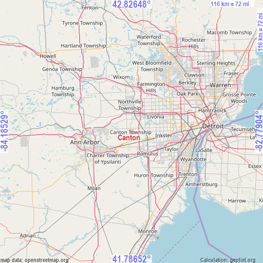
Canton GPS coordinates[2]
42° 18' 31.14" North, 83° 28' 55.776" West
| Map corner | latitude | longitude |
|---|---|---|
| Upper-left | 42.82648°, | -84.18529° |
| Center: | 42.30865°, | -83.48216° |
| Lower-right: | 41.78652°, | -82.77904° |
| Map W x H: | 115.6×115.6 km | = 71.8×71.8mi |
| max Lat: | 71.29058° ⇑21.8% North |
| Canton: | 42.30865° |
| min Lat: | ⇓78.2% South 19.06759° |
| min Long | Canton | max Long |
| -171.73463° | -83.48216° | -66.98998° |
| W 60.7%⇐ | ⇒39.3% E |
Elevation
Elevation of Canton is 209 m = 686 ft, and this is 85.8 m = 281 ft below average elevation for this country.
| Max E: |
3189 m = 10463 ft | 47.2% |
| Avg. | 294.8 m = 967 ft | |
| Canton | 209 m = 686 ft | |
Min E: |
-60 m = -197 ft | 52.8% |
See also: Canton elevation on elevation.city.
Geographical zone
Canton is located in North temperate zone (between Tropic of Cancer and the Arctic Circle). Distance of this Northern Tropic circle is 2098.4 km =1303.9 mi to South.| Distance of | km | miles | from Canton |
|---|---|---|---|
| North Pole | 5302.8 | 3295 | to North |
| Arctic Circle | 2696.9 | 1675.8 | to North |
| Tropic Cancer | 2098.4 | 1303.9 | to South |
| Equator | 4704.3 | 2923.1 | to South |


Nearby cities:
15 places around Canton: (largest is in red/bold)
• Belleville
11.6 km =7.2 mi,  181°
181°
• Dearborn Heights
17.5 km =10.9 mi,  79°
79°
• Farmington
19.4 km =12.1 mi,  26°
26°
• Garden City
12.6 km =7.8 mi, 81°
• Inkster
14.3 km =8.9 mi,  96°
96°
• Livonia
12.5 km =7.8 mi,  58°
58°
• Northville
13.6 km =8.5 mi,  359°
359°
• Novi
19.1 km =11.9 mi,  1°
1°
• Plymouth
7 km =4.3 mi,  8°
8°
• Redford
17.4 km =10.8 mi, 61°
• Romulus
11.9 km =7.4 mi,  143°
143°
• Taylor
19 km =11.8 mi,  113°
113°
• Wayne
8.4 km =5.2 mi, 111°
• Westland
7 km =4.3 mi, 75°
• Ypsilanti
13.1 km =8.1 mi,  235°
235°
Sources, notices
• [Note1] Compared only with cities in United States existing in our database
• [Src1] Map data: © OpenStreetMap contributors (CC-BY-SA)
• [Src2] Other city data from geonames.org with taken over terms of usage.
• [Src3] Geographical zone / Annual Mean Temperature by Robert A. Rohde @ Wikipedia
