Holland geodata
Holland (Michigan) is a populated place; located in United States in America/Detroit (GMT-4) time zone. With population of 33,742 people, there are 1467 cities with bigger population in this country. Compared to other cities in United States, 81.8% of cities are located further ↓South; 52.6% of cities are located further ←West and 52.5% of cities have higher elevation than Holland. Note1


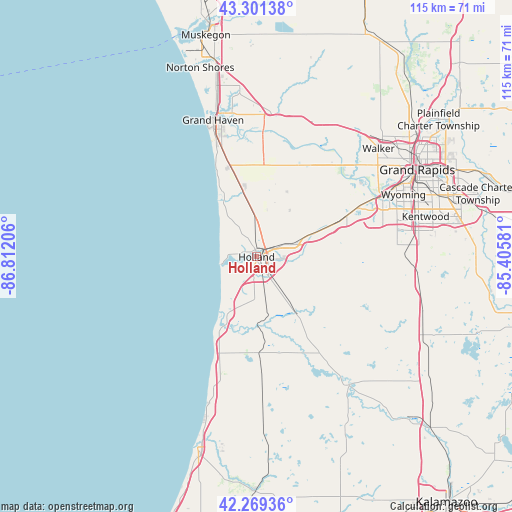
Holland GPS coordinates[2]
42° 47' 15.072" North, 86° 6' 32.148" West
| Map corner | latitude | longitude |
|---|---|---|
| Upper-left | 43.30138°, | -86.81206° |
| Center: | 42.78752°, | -86.10893° |
| Lower-right: | 42.26936°, | -85.40581° |
| Map W x H: | 114.7×114.7 km | = 71.3×71.3mi |
| max Lat: | 71.29058° ⇑18.2% North |
| Holland: | 42.78752° |
| min Lat: | ⇓81.8% South 19.06759° |
| min Long | Holland | max Long |
| -171.73463° | -86.10893° | -66.98998° |
| W 52.6%⇐ | ⇒47.4% E |
Elevation
Elevation of Holland is 189 m = 620 ft, and this is 105.8 m = 347 ft below average elevation for this country.
| Max E: |
3189 m = 10463 ft | 52.5% |
| Avg. | 294.8 m = 967 ft | |
| Holland | 189 m = 620 ft | |
Min E: |
-60 m = -197 ft | 47.5% |
See also: United States elevation on elevation.city.
Geographical zone
Holland is located in North temperate zone (between Tropic of Cancer and the Arctic Circle). Distance of this Northern Tropic circle is 2151.6 km =1336.9 mi to South.| Distance of | km | miles | from Holland |
|---|---|---|---|
| North Pole | 5249.5 | 3261.9 | to North |
| Arctic Circle | 2643.6 | 1642.7 | to North |
| Tropic Cancer | 2151.6 | 1336.9 | to South |
| Equator | 4757.5 | 2956.2 | to South |


Nearby cities:
15 places around Holland: (largest is in red/bold)
• Allendale
24.1 km =15 mi,  31°
31°
• Beechwood
1.7 km =1.1 mi,  307°
307°
• Byron Center
31.6 km =19.6 mi,  85°
85°
• Coopersville
33.8 km =21 mi,  24°
24°
• Douglas
17.7 km =11 mi,  205°
205°
• Fennville
21.5 km =13.4 mi,  178°
178°
• Ferrysburg
34.2 km =21.3 mi,  344°
344°
• Grand Haven
32.1 km =19.9 mi, 342°
• Grandville
31.3 km =19.4 mi,  64°
64°
• Hopkins
33.8 km =21 mi,  122°
122°
• Hudsonville
21.9 km =13.6 mi,  65°
65°
• Jenison
29.1 km =18.1 mi, 62°
• Saugatuck
16.6 km =10.3 mi, 207°
• Spring Lake
33 km =20.5 mi,  347°
347°
• Zeeland
7.9 km =4.9 mi, 69°
Sources, notices
• [Note1] Compared only with cities in United States existing in our database
• [Src1] Map data: © OpenStreetMap contributors (CC-BY-SA)
• [Src2] Other city data from geonames.org with taken over terms of usage.
• [Src3] Geographical zone / Annual Mean Temperature by Robert A. Rohde @ Wikipedia
