Saugatuck geodata
Saugatuck (Michigan) is a populated place; located in United States in America/Detroit (GMT-4) time zone. With population of 964 people, there are 16535 cities with bigger population in this country. Compared to other cities in United States, 81% of cities are located further ↓South; 52.4% of cities are located further ←West and 54.8% of cities have higher elevation than Saugatuck. Note1


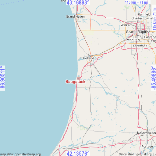
Saugatuck GPS coordinates[2]
42° 39' 18.072" North, 86° 12' 7.128" West
| Map corner | latitude | longitude |
|---|---|---|
| Upper-left | 43.16998°, | -86.90511° |
| Center: | 42.65502°, | -86.20198° |
| Lower-right: | 42.13576°, | -85.49886° |
| Map W x H: | 115×115 km | = 71.5×71.5mi |
| max Lat: | 71.29058° ⇑19% North |
| Saugatuck: | 42.65502° |
| min Lat: | ⇓81% South 19.06759° |
| min Long | Saugatuck | max Long |
| -171.73463° | -86.20198° | -66.98998° |
| W 52.4%⇐ | ⇒47.6% E |
Elevation
Elevation of Saugatuck is 181 m = 594 ft, and this is 113.8 m = 373 ft below average elevation for this country.
| Max E: |
3189 m = 10463 ft | 54.8% |
| Avg. | 294.8 m = 967 ft | |
| Saugatuck | 181 m = 594 ft | |
Min E: |
-60 m = -197 ft | 45.2% |
See also: United States elevation on elevation.city.
Geographical zone
Saugatuck is located in North temperate zone (between Tropic of Cancer and the Arctic Circle). Distance of this Northern Tropic circle is 2136.9 km =1327.8 mi to South.| Distance of | km | miles | from Saugatuck |
|---|---|---|---|
| North Pole | 5264.3 | 3271.1 | to North |
| Arctic Circle | 2658.4 | 1651.9 | to North |
| Tropic Cancer | 2136.9 | 1327.8 | to South |
| Equator | 4742.8 | 2947 | to South |


Nearby cities:
15 places around Saugatuck: (largest is in red/bold)
• Allegan
31.6 km =19.6 mi,  116°
116°
• Allendale
40.7 km =25.3 mi,  29°
29°
• Bangor
38.8 km =24.1 mi,  169°
169°
• Beechwood
17 km =10.6 mi,  21°
21°
• Byron Center
42.9 km =26.7 mi,  65°
65°
• Douglas
1.3 km =0.8 mi, 174°
• Fennville
10.7 km =6.6 mi,  129°
129°
• Gobles
42.1 km =26.2 mi,  141°
141°
• Grand Haven
45.4 km =28.2 mi,  357°
357°
• Holland
16.6 km =10.3 mi, 27°
• Hopkins
36.3 km =22.6 mi,  95°
95°
• Hudsonville
36.5 km =22.7 mi,  48°
48°
• Jenison
43.7 km =27.2 mi, 50°
• South Haven
28.6 km =17.8 mi,  191°
191°
• Zeeland
23 km =14.3 mi,  40°
40°
Sources, notices
• [Note1] Compared only with cities in United States existing in our database
• [Src1] Map data: © OpenStreetMap contributors (CC-BY-SA)
• [Src2] Other city data from geonames.org with taken over terms of usage.
• [Src3] Geographical zone / Annual Mean Temperature by Robert A. Rohde @ Wikipedia
