Ithaca geodata
Ithaca (Michigan) is a seat of a second-order administrative division; located in United States in America/Detroit (GMT-4) time zone. With population of 2,834 people, there are 9938 cities with bigger population in this country. Compared to other cities in United States, 85.3% of cities are located further ↓South; 56.9% of cities are located further ←West and 60.3% of cities have lower elevation than Ithaca. Note1


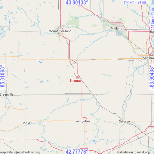
Ithaca GPS coordinates[2]
43° 17' 30.12" North, 84° 36' 27" West
| Map corner | latitude | longitude |
|---|---|---|
| Upper-left | 43.80133°, | -85.31063° |
| Center: | 43.2917°, | -84.6075° |
| Lower-right: | 42.77776°, | -83.90438° |
| Map W x H: | 113.8×113.8 km | = 70.7×70.7mi |
| max Lat: | 71.29058° ⇑14.7% North |
| Ithaca: | 43.2917° |
| min Lat: | ⇓85.3% South 19.06759° |
| min Long | Ithaca | max Long |
| -171.73463° | -84.6075° | -66.98998° |
| W 56.9%⇐ | ⇒43.1% E |
Elevation
Elevation of Ithaca is 241 m = 791 ft, and this is 53.8 m = 177 ft below average elevation for this country.
| Max E: |
3189 m = 10463 ft | 39.7% |
| Avg. | 294.8 m = 967 ft | |
| Ithaca | 241 m = 791 ft | |
Min E: |
-60 m = -197 ft | 60.3% |
See also: United States elevation on elevation.city.
Geographical zone
Ithaca is located in North temperate zone (between Tropic of Cancer and the Arctic Circle). Distance of this Northern Tropic circle is 2207.7 km =1371.8 mi to South.| Distance of | km | miles | from Ithaca |
|---|---|---|---|
| North Pole | 5193.5 | 3227.1 | to North |
| Arctic Circle | 2587.6 | 1607.9 | to North |
| Tropic Cancer | 2207.7 | 1371.8 | to South |
| Equator | 4813.6 | 2991 | to South |


Nearby cities:
15 places around Ithaca: (largest is in red/bold)
• Alma
10.6 km =6.6 mi,  336°
336°
• Ashley
15.9 km =9.9 mi,  137°
137°
• Breckenridge
16.8 km =10.4 mi,  39°
39°
• Carson City
23.2 km =14.4 mi,  236°
236°
• Edmore
37.2 km =23.1 mi,  290°
290°
• Elsie
28.8 km =17.9 mi, 141°
• Fowler
34 km =21.1 mi,  198°
198°
• Hemlock
33.4 km =20.8 mi,  65°
65°
• Maple Rapids
21.9 km =13.6 mi, 198°
• Merrill
26.1 km =16.2 mi,  59°
59°
• Mount Pleasant
36.4 km =22.6 mi, 339°
• Ovid
37.1 km =23.1 mi,  148°
148°
• Saint Johns
32.5 km =20.2 mi,  173°
173°
• Saint Louis
13 km =8.1 mi,  0°
0°
• Shepherd
26.8 km =16.7 mi, 344°
Sources, notices
• [Note1] Compared only with cities in United States existing in our database
• [Src1] Map data: © OpenStreetMap contributors (CC-BY-SA)
• [Src2] Other city data from geonames.org with taken over terms of usage.
• [Src3] Geographical zone / Annual Mean Temperature by Robert A. Rohde @ Wikipedia
