Negaunee geodata
Negaunee (Michigan) is a populated place; located in United States in America/Detroit (GMT-4) time zone. With population of 4,582 people, there are 7563 cities with bigger population in this country. Compared to other cities in United States, 95.8% of cities are located further ↓South; 51% of cities are located further →East and 84.6% of cities have lower elevation than Negaunee. Note1


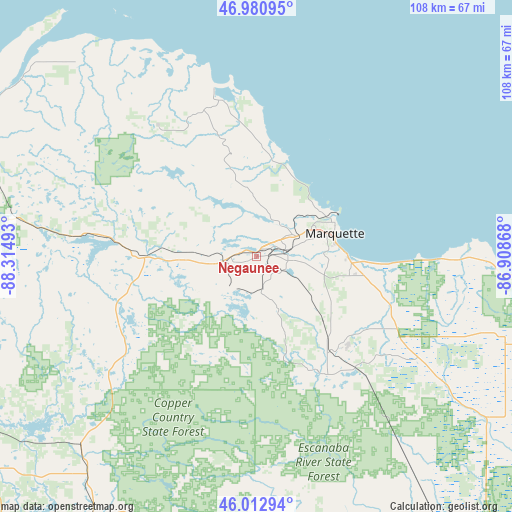
Negaunee GPS coordinates[2]
46° 29' 56.76" North, 87° 36' 42.48" West
| Map corner | latitude | longitude |
|---|---|---|
| Upper-left | 46.98095°, | -88.31493° |
| Center: | 46.4991°, | -87.6118° |
| Lower-right: | 46.01294°, | -86.90868° |
| Map W x H: | 107.6×107.6 km | = 66.9×66.9mi |
| max Lat: | 71.29058° ⇑4.2% North |
| Negaunee: | 46.4991° |
| min Lat: | ⇓95.8% South 19.06759° |
| min Long | Negaunee | max Long |
| -171.73463° | -87.6118° | -66.98998° |
| W 49%⇐ | ⇒51% E |
Elevation
Elevation of Negaunee is 416 m = 1365 ft, and this is 121.2 m = 398 ft above average elevation for this country.
| Max E: |
3189 m = 10463 ft | 15.4% |
| Negaunee | 416 m 1365 ft | |
| Avg. | 294.8 m = 967 ft | |
Min E: |
-60 m = -197 ft | 84.6% |
See also: United States elevation on elevation.city.
Geographical zone
Negaunee is located in North temperate zone (between Tropic of Cancer and the Arctic Circle). Distance of this North polar circle is 2231 km =1386.3 mi to North.| Distance of | km | miles | from Negaunee |
|---|---|---|---|
| North Pole | 4836.8 | 3005.4 | to North |
| Arctic Circle | 2231 | 1386.3 | to North |
| Tropic Cancer | 2564.3 | 1593.4 | to South |
| Equator | 5170.2 | 3212.6 | to South |


Nearby cities:
15 places around Negaunee: (largest is in red/bold)
• Baraga
73.8 km =45.9 mi,  294°
294°
• Crystal Falls
71.2 km =44.2 mi,  231°
231°
• Florence
80.9 km =50.3 mi,  217°
217°
• Gwinn
27.6 km =17.1 mi,  151°
151°
• Harvey
19.7 km =12.2 mi,  91°
91°
• Ishpeming
4.4 km =2.7 mi,  254°
254°
• K. I. Sawyer Air Force Base
24.2 km =15 mi,  134°
134°
• L'Anse
70.3 km =43.7 mi, 294°
• Marquette
17.3 km =10.7 mi,  73°
73°
• Munising
74.4 km =46.2 mi,  97°
97°
• Norway
82.3 km =51.1 mi,  195°
195°
• Quinnesec
82.3 km =51.1 mi, 200°
• Republic
29.7 km =18.5 mi, 249°
• Trowbridge Park
14.8 km =9.2 mi,  64°
64°
• West Ishpeming
7 km =4.3 mi,  255°
255°
Sources, notices
• [Note1] Compared only with cities in United States existing in our database
• [Src1] Map data: © OpenStreetMap contributors (CC-BY-SA)
• [Src2] Other city data from geonames.org with taken over terms of usage.
• [Src3] Geographical zone / Annual Mean Temperature by Robert A. Rohde @ Wikipedia
