Bloomington geodata
Bloomington (Minnesota) is a populated place; located in United States in America/Chicago (GMT-5) time zone. With population of 86,435 people, there are 443 cities with bigger population in this country. Compared to other cities in United States, 91.8% of cities are located further ↓South; 67% of cities are located further →East and 62.6% of cities have lower elevation than Bloomington. Note1
Administrative division(s):
- Level 1: Minnesota
- Level 2: Hennepin County
- Level 3: City of Bloomington


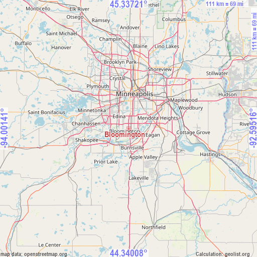
Bloomington GPS coordinates[2]
44° 50' 26.88" North, 93° 17' 53.808" West
| Map corner | latitude | longitude |
|---|---|---|
| Upper-left | 45.33721°, | -94.00141° |
| Center: | 44.8408°, | -93.29828° |
| Lower-right: | 44.34008°, | -92.59516° |
| Map W x H: | 110.9×110.9 km | = 68.9×68.9mi |
| max Lat: | 71.29058° ⇑8.2% North |
| Bloomington: | 44.8408° |
| min Lat: | ⇓91.8% South 19.06759° |
| min Long | Bloomington | max Long |
| -171.73463° | -93.29828° | -66.98998° |
| W 33%⇐ | ⇒67% E |
Elevation
Elevation of Bloomington is 251 m = 823 ft, and this is 43.8 m = 144 ft below average elevation for this country.
| Max E: |
3189 m = 10463 ft | 37.4% |
| Avg. | 294.8 m = 967 ft | |
| Bloomington | 251 m = 823 ft | |
Min E: |
-60 m = -197 ft | 62.6% |
See also: Bloomington elevation on elevation.city.
Geographical zone
Bloomington is located in North temperate zone (between Tropic of Cancer and the Arctic Circle). Distance of this Northern Tropic circle is 2379.9 km =1478.8 mi to South.| Distance of | km | miles | from Bloomington |
|---|---|---|---|
| North Pole | 5021.2 | 3120 | to North |
| Arctic Circle | 2415.3 | 1500.8 | to North |
| Tropic Cancer | 2379.9 | 1478.8 | to South |
| Equator | 4985.8 | 3098 | to South |


Nearby cities:
15 places around Bloomington: (largest is in red/bold)
• Apple Valley
13.7 km =8.5 mi,  152°
152°
• Burnsville
8.3 km =5.2 mi,  168°
168°
• Eagan
11.1 km =6.9 mi,  111°
111°
• Eden Prairie
13.7 km =8.5 mi,  276°
276°
• Edina
6.8 km =4.2 mi,  323°
323°
• Hopkins
16 km =9.9 mi,  305°
305°
• Lilydale
15.9 km =9.9 mi,  58°
58°
• Mendota Heights
13.5 km =8.4 mi,  69°
69°
• Minneapolis
15.7 km =9.8 mi,  9°
9°
• Minnetonka Mills
15.9 km =9.9 mi, 314°
• Prior Lake
17.2 km =10.7 mi,  214°
214°
• Richfield
4.9 km =3 mi, 14°
• Saint Louis Park
12.6 km =7.8 mi,  341°
341°
• Savage
7.5 km =4.7 mi,  203°
203°
• Sunfish Lake
16.1 km =10 mi,  78°
78°
Sources, notices
• [Note1] Compared only with cities in United States existing in our database
• [Src1] Map data: © OpenStreetMap contributors (CC-BY-SA)
• [Src2] Other city data from geonames.org with taken over terms of usage.
• [Src3] Geographical zone / Annual Mean Temperature by Robert A. Rohde @ Wikipedia
