Burnsville geodata
Burnsville (Minnesota) is a populated place; located in United States in America/Chicago (GMT-5) time zone. With population of 61,481 people, there are 713 cities with bigger population in this country. Compared to other cities in United States, 91.5% of cities are located further ↓South; 66.9% of cities are located further →East and 71.8% of cities have lower elevation than Burnsville. Note1


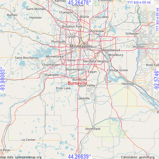
Burnsville GPS coordinates[2]
44° 46' 3.864" North, 93° 16' 39.792" West
| Map corner | latitude | longitude |
|---|---|---|
| Upper-left | 45.26478°, | -93.98085° |
| Center: | 44.76774°, | -93.27772° |
| Lower-right: | 44.26639°, | -92.5746° |
| Map W x H: | 111×111 km | = 69×69mi |
| max Lat: | 71.29058° ⇑8.5% North |
| Burnsville: | 44.76774° |
| min Lat: | ⇓91.5% South 19.06759° |
| min Long | Burnsville | max Long |
| -171.73463° | -93.27772° | -66.98998° |
| W 33.1%⇐ | ⇒66.9% E |
Elevation
Elevation of Burnsville is 295 m = 968 ft, and this is 0.19999999999999 m = 1 ft above average elevation for this country.
| Max E: |
3189 m = 10463 ft | 28.2% |
| Burnsville | 295 m 968 ft | |
| Avg. | 294.8 m = 967 ft | |
Min E: |
-60 m = -197 ft | 71.8% |
See also: Burnsville elevation on elevation.city.
Geographical zone
Burnsville is located in North temperate zone (between Tropic of Cancer and the Arctic Circle). Distance of this Northern Tropic circle is 2371.8 km =1473.8 mi to South.| Distance of | km | miles | from Burnsville |
|---|---|---|---|
| North Pole | 5029.4 | 3125.1 | to North |
| Arctic Circle | 2423.5 | 1505.9 | to North |
| Tropic Cancer | 2371.8 | 1473.8 | to South |
| Equator | 4977.7 | 3093 | to South |


Nearby cities:
15 places around Burnsville: (largest is in red/bold)
• Apple Valley
6.2 km =3.9 mi,  130°
130°
• Bloomington
8.3 km =5.2 mi,  348°
348°
• Eagan
9.6 km =6 mi,  65°
65°
• Eden Prairie
18 km =11.2 mi,  302°
302°
• Edina
14.7 km =9.1 mi,  337°
337°
• Farmington
17.7 km =11 mi,  143°
143°
• Lakeville
13.4 km =8.3 mi,  168°
168°
• Lilydale
20.4 km =12.7 mi,  35°
35°
• Mendota Heights
16.9 km =10.5 mi, 40°
• Prior Lake
13 km =8.1 mi,  242°
242°
• Richfield
12.9 km =8 mi,  358°
358°
• Rosemount
12.4 km =7.7 mi,  104°
104°
• Savage
4.8 km =3 mi,  285°
285°
• Shakopee
20 km =12.4 mi,  279°
279°
• Sunfish Lake
18.2 km =11.3 mi,  50°
50°
Sources, notices
• [Note1] Compared only with cities in United States existing in our database
• [Src1] Map data: © OpenStreetMap contributors (CC-BY-SA)
• [Src2] Other city data from geonames.org with taken over terms of usage.
• [Src3] Geographical zone / Annual Mean Temperature by Robert A. Rohde @ Wikipedia
