Eagan geodata
Eagan (Minnesota) is a populated place; located in United States in America/Chicago (GMT-5) time zone. With population of 66,286 people, there are 643 cities with bigger population in this country. Compared to other cities in United States, 91.7% of cities are located further ↓South; 66.6% of cities are located further →East and 70.6% of cities have lower elevation than Eagan. Note1


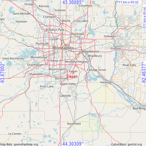
Eagan GPS coordinates[2]
44° 48' 14.868" North, 93° 10' 0.804" West
| Map corner | latitude | longitude |
|---|---|---|
| Upper-left | 45.30085°, | -93.87002° |
| Center: | 44.80413°, | -93.16689° |
| Lower-right: | 44.30309°, | -92.46377° |
| Map W x H: | 110.9×110.9 km | = 68.9×68.9mi |
| max Lat: | 71.29058° ⇑8.3% North |
| Eagan: | 44.80413° |
| min Lat: | ⇓91.7% South 19.06759° |
| min Long | Eagan | max Long |
| -171.73463° | -93.16689° | -66.98998° |
| W 33.4%⇐ | ⇒66.6% E |
Elevation
Elevation of Eagan is 289 m = 948 ft, and this is 5.8 m = 19 ft below average elevation for this country.
| Max E: |
3189 m = 10463 ft | 29.4% |
| Avg. | 294.8 m = 967 ft | |
| Eagan | 289 m = 948 ft | |
Min E: |
-60 m = -197 ft | 70.6% |
See also: Eagan elevation on elevation.city.
Geographical zone
Eagan is located in North temperate zone (between Tropic of Cancer and the Arctic Circle). Distance of this Northern Tropic circle is 2375.8 km =1476.3 mi to South.| Distance of | km | miles | from Eagan |
|---|---|---|---|
| North Pole | 5025.3 | 3122.6 | to North |
| Arctic Circle | 2419.4 | 1503.3 | to North |
| Tropic Cancer | 2375.8 | 1476.3 | to South |
| Equator | 4981.8 | 3095.5 | to South |


Nearby cities:
15 places around Eagan: (largest is in red/bold)
• Apple Valley
9 km =5.6 mi,  206°
206°
• Bloomington
11.1 km =6.9 mi,  291°
291°
• Burnsville
9.6 km =6 mi,  245°
245°
• Inver Grove Heights
10.9 km =6.8 mi,  63°
63°
• Lilydale
12.9 km =8 mi,  14°
14°
• Mendota Heights
9.1 km =5.7 mi, 14°
• Newport
14.8 km =9.2 mi, 62°
• Richfield
12.7 km =7.9 mi,  313°
313°
• Rosemount
7.9 km =4.9 mi,  155°
155°
• Saint Paul
16.6 km =10.3 mi,  20°
20°
• Saint Paul Park
14.5 km =9 mi,  73°
73°
• Savage
13.7 km =8.5 mi,  258°
258°
• South Saint Paul
14.3 km =8.9 mi,  46°
46°
• Sunfish Lake
9.2 km =5.7 mi,  36°
36°
• West Saint Paul
13.5 km =8.4 mi, 22°
Sources, notices
• [Note1] Compared only with cities in United States existing in our database
• [Src1] Map data: © OpenStreetMap contributors (CC-BY-SA)
• [Src2] Other city data from geonames.org with taken over terms of usage.
• [Src3] Geographical zone / Annual Mean Temperature by Robert A. Rohde @ Wikipedia
