Apple Valley geodata
Apple Valley (Minnesota) is a populated place; located in United States in America/Chicago (GMT-5) time zone. With population of 51,221 people, there are 930 cities with bigger population in this country. Compared to other cities in United States, 91.3% of cities are located further ↓South; 66.8% of cities are located further →East and 70.4% of cities have lower elevation than Apple Valley. Note1


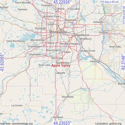
Apple Valley GPS coordinates[2]
44° 43' 54.876" North, 93° 13' 3.792" West
| Map corner | latitude | longitude |
|---|---|---|
| Upper-left | 45.22926°, | -93.92085° |
| Center: | 44.73191°, | -93.21772° |
| Lower-right: | 44.23025°, | -92.5146° |
| Map W x H: | 111.1×111.1 km | = 69×69mi |
| max Lat: | 71.29058° ⇑8.7% North |
| Apple Valley: | 44.73191° |
| min Lat: | ⇓91.3% South 19.06759° |
| min Long | Apple Valley | max Long |
| -171.73463° | -93.21772° | -66.98998° |
| W 33.2%⇐ | ⇒66.8% E |
Elevation
Elevation of Apple Valley is 288 m = 945 ft, and this is 6.8 m = 22 ft below average elevation for this country.
| Max E: |
3189 m = 10463 ft | 29.6% |
| Avg. | 294.8 m = 967 ft | |
| Apple Valley | 288 m = 945 ft | |
Min E: |
-60 m = -197 ft | 70.4% |
See also: Apple Valley elevation on elevation.city.
Geographical zone
Apple Valley is located in North temperate zone (between Tropic of Cancer and the Arctic Circle). Distance of this Northern Tropic circle is 2367.8 km =1471.3 mi to South.| Distance of | km | miles | from Apple Valley |
|---|---|---|---|
| North Pole | 5033.3 | 3127.5 | to North |
| Arctic Circle | 2427.5 | 1508.4 | to North |
| Tropic Cancer | 2367.8 | 1471.3 | to South |
| Equator | 4973.7 | 3090.5 | to South |


Nearby cities:
15 places around Apple Valley: (largest is in red/bold)
• Bloomington
13.7 km =8.5 mi,  332°
332°
• Burnsville
6.2 km =3.9 mi,  310°
310°
• Eagan
9 km =5.6 mi,  26°
26°
• Edina
20.4 km =12.7 mi, 329°
• Elko
20.5 km =12.7 mi,  204°
204°
• Elko New Market
20.5 km =12.7 mi, 204°
• Farmington
11.8 km =7.3 mi,  150°
150°
• Inver Grove Heights
18.9 km =11.7 mi,  46°
46°
• Lakeville
9.4 km =5.8 mi,  192°
192°
• Mendota Heights
18 km =11.2 mi,  20°
20°
• Prior Lake
16.3 km =10.1 mi,  262°
262°
• Richfield
17.6 km =10.9 mi,  342°
342°
• Rosemount
7.3 km =4.5 mi,  83°
83°
• Savage
10.7 km =6.6 mi,  299°
299°
• Sunfish Lake
18.1 km =11.2 mi, 31°
Sources, notices
• [Note1] Compared only with cities in United States existing in our database
• [Src1] Map data: © OpenStreetMap contributors (CC-BY-SA)
• [Src2] Other city data from geonames.org with taken over terms of usage.
• [Src3] Geographical zone / Annual Mean Temperature by Robert A. Rohde @ Wikipedia
