Edina geodata
Edina (Minnesota) is a populated place; located in United States in America/Chicago (GMT-5) time zone. With population of 50,138 people, there are 948 cities with bigger population in this country. Compared to other cities in United States, 92% of cities are located further ↓South; 67.1% of cities are located further →East and 68% of cities have lower elevation than Edina. Note1


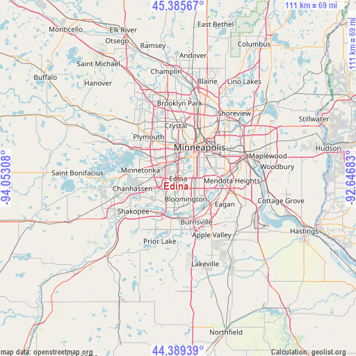
Edina GPS coordinates[2]
44° 53' 22.884" North, 93° 20' 59.82" West
| Map corner | latitude | longitude |
|---|---|---|
| Upper-left | 45.38567°, | -94.05308° |
| Center: | 44.88969°, | -93.34995° |
| Lower-right: | 44.38939°, | -92.64683° |
| Map W x H: | 110.8×110.8 km | = 68.8×68.8mi |
| max Lat: | 71.29058° ⇑8% North |
| Edina: | 44.88969° |
| min Lat: | ⇓92% South 19.06759° |
| min Long | Edina | max Long |
| -171.73463° | -93.34995° | -66.98998° |
| W 32.9%⇐ | ⇒67.1% E |
Elevation
Elevation of Edina is 276 m = 906 ft, and this is 18.8 m = 62 ft below average elevation for this country.
| Max E: |
3189 m = 10463 ft | 32% |
| Avg. | 294.8 m = 967 ft | |
| Edina | 276 m = 906 ft | |
Min E: |
-60 m = -197 ft | 68% |
See also: Edina elevation on elevation.city.
Geographical zone
Edina is located in North temperate zone (between Tropic of Cancer and the Arctic Circle). Distance of this Northern Tropic circle is 2385.3 km =1482.2 mi to South.| Distance of | km | miles | from Edina |
|---|---|---|---|
| North Pole | 5015.8 | 3116.7 | to North |
| Arctic Circle | 2409.9 | 1497.4 | to North |
| Tropic Cancer | 2385.3 | 1482.2 | to South |
| Equator | 4991.3 | 3101.4 | to South |


Nearby cities:
15 places around Edina: (largest is in red/bold)
• Bloomington
6.8 km =4.2 mi,  143°
143°
• Burnsville
14.7 km =9.1 mi,  157°
157°
• Chanhassen
14.6 km =9.1 mi,  257°
257°
• Deephaven
14.3 km =8.9 mi,  288°
288°
• Eden Prairie
10.3 km =6.4 mi,  247°
247°
• Golden Valley
13.3 km =8.3 mi,  0°
0°
• Hopkins
9.7 km =6 mi, 293°
• Minneapolis
12.1 km =7.5 mi,  34°
34°
• Minnetonka
12.4 km =7.7 mi,  282°
282°
• Minnetonka Mills
9.2 km =5.7 mi,  308°
308°
• Plymouth
15.8 km =9.8 mi,  328°
328°
• Richfield
5.3 km =3.3 mi,  97°
97°
• Saint Louis Park
6.5 km =4 mi, 1°
• Savage
12.3 km =7.6 mi,  175°
175°
• Wayzata
15.5 km =9.6 mi, 307°
Sources, notices
• [Note1] Compared only with cities in United States existing in our database
• [Src1] Map data: © OpenStreetMap contributors (CC-BY-SA)
• [Src2] Other city data from geonames.org with taken over terms of usage.
• [Src3] Geographical zone / Annual Mean Temperature by Robert A. Rohde @ Wikipedia
