Cook geodata
Cook (Minnesota) is a populated place; located in United States in America/Chicago (GMT-5) time zone. With population of 567 people, there are 20064 cities with bigger population in this country. Compared to other cities in United States, 98.4% of cities are located further ↓South; 65.6% of cities are located further →East and 83.4% of cities have lower elevation than Cook. Note1


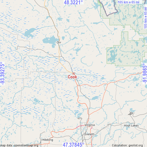
Cook GPS coordinates[2]
47° 51' 8.712" North, 92° 41' 22.632" West
| Map corner | latitude | longitude |
|---|---|---|
| Upper-left | 48.3221°, | -93.39275° |
| Center: | 47.85242°, | -92.68962° |
| Lower-right: | 47.37845°, | -91.9865° |
| Map W x H: | 104.9×104.9 km | = 65.2×65.2mi |
| max Lat: | 71.29058° ⇑1.6% North |
| Cook: | 47.85242° |
| min Lat: | ⇓98.4% South 19.06759° |
| min Long | Cook | max Long |
| -171.73463° | -92.68962° | -66.98998° |
| W 34.4%⇐ | ⇒65.6% E |
Elevation
Elevation of Cook is 396 m = 1299 ft, and this is 101.2 m = 332 ft above average elevation for this country.
| Max E: |
3189 m = 10463 ft | 16.6% |
| Cook | 396 m 1299 ft | |
| Avg. | 294.8 m = 967 ft | |
Min E: |
-60 m = -197 ft | 83.4% |
See also: United States elevation on elevation.city.
Geographical zone
Cook is located in North temperate zone (between Tropic of Cancer and the Arctic Circle). Distance of this North polar circle is 2080.5 km =1292.8 mi to North.| Distance of | km | miles | from Cook |
|---|---|---|---|
| North Pole | 4686.4 | 2912 | to North |
| Arctic Circle | 2080.5 | 1292.8 | to North |
| Tropic Cancer | 2714.8 | 1686.9 | to South |
| Equator | 5320.7 | 3306.1 | to South |


Nearby cities:
15 places around Cook: (largest is in red/bold)
• Aurora
49.3 km =30.6 mi,  136°
136°
• Babbitt
57.9 km =36 mi,  106°
106°
• Biwabik
44.1 km =27.4 mi, 143°
• Buhl
40.4 km =25.1 mi,  189°
189°
• Chisholm
42.9 km =26.7 mi,  199°
199°
• Ely
61.6 km =38.3 mi,  84°
84°
• Eveleth
44.8 km =27.8 mi,  165°
165°
• Gilbert
43.8 km =27.2 mi,  157°
157°
• Hibbing
50.8 km =31.6 mi, 201°
• Hoyt Lakes
55.4 km =34.4 mi,  131°
131°
• Keewatin
57.9 km =36 mi,  209°
209°
• Mountain Iron
35.9 km =22.3 mi, 172°
• Nashwauk
63.6 km =39.5 mi, 214°
• Parkville
36.7 km =22.8 mi, 166°
• Virginia
38.4 km =23.9 mi, 162°
Sources, notices
• [Note1] Compared only with cities in United States existing in our database
• [Src1] Map data: © OpenStreetMap contributors (CC-BY-SA)
• [Src2] Other city data from geonames.org with taken over terms of usage.
• [Src3] Geographical zone / Annual Mean Temperature by Robert A. Rohde @ Wikipedia
