Buhl geodata
Buhl (Minnesota) is a populated place; located in United States in America/Chicago (GMT-5) time zone. With population of 990 people, there are 16344 cities with bigger population in this country. Compared to other cities in United States, 97.6% of cities are located further ↓South; 65.8% of cities are located further →East and 86.8% of cities have lower elevation than Buhl. Note1


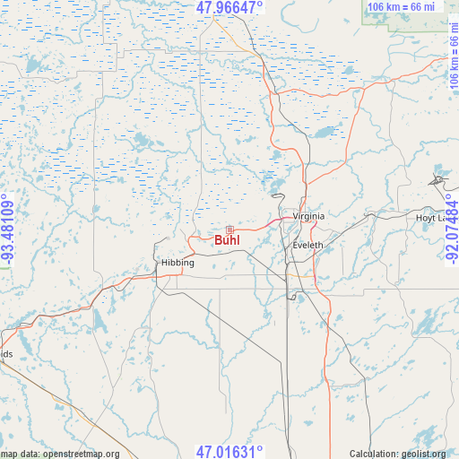
Buhl GPS coordinates[2]
47° 29' 36.744" North, 92° 46' 40.656" West
| Map corner | latitude | longitude |
|---|---|---|
| Upper-left | 47.96647°, | -93.48109° |
| Center: | 47.49354°, | -92.77796° |
| Lower-right: | 47.01631°, | -92.07484° |
| Map W x H: | 105.6×105.6 km | = 65.6×65.6mi |
| max Lat: | 71.29058° ⇑2.4% North |
| Buhl: | 47.49354° |
| min Lat: | ⇓97.6% South 19.06759° |
| min Long | Buhl | max Long |
| -171.73463° | -92.77796° | -66.98998° |
| W 34.2%⇐ | ⇒65.8% E |
Elevation
Elevation of Buhl is 464 m = 1522 ft, and this is 169.2 m = 555 ft above average elevation for this country.
| Max E: |
3189 m = 10463 ft | 13.2% |
| Buhl | 464 m 1522 ft | |
| Avg. | 294.8 m = 967 ft | |
Min E: |
-60 m = -197 ft | 86.8% |
See also: United States elevation on elevation.city.
Geographical zone
Buhl is located in North temperate zone (between Tropic of Cancer and the Arctic Circle). Distance of this North polar circle is 2120.4 km =1317.6 mi to North.| Distance of | km | miles | from Buhl |
|---|---|---|---|
| North Pole | 4726.3 | 2936.8 | to North |
| Arctic Circle | 2120.4 | 1317.6 | to North |
| Tropic Cancer | 2674.9 | 1662.1 | to South |
| Equator | 5280.8 | 3281.3 | to South |


Nearby cities:
15 places around Buhl: (largest is in red/bold)
• Aurora
40.8 km =25.4 mi,  84°
84°
• Biwabik
33.2 km =20.6 mi, 82°
• Chisholm
8 km =5 mi,  266°
266°
• Cook
40.4 km =25.1 mi,  9°
9°
• Eveleth
18.2 km =11.3 mi,  100°
100°
• Gilbert
23.5 km =14.6 mi,  91°
91°
• Hibbing
14.1 km =8.8 mi,  238°
238°
• Hoyt Lakes
48.1 km =29.9 mi, 86°
• Keewatin
24.5 km =15.2 mi, 244°
• Marble
43.6 km =27.1 mi, 243°
• Mountain Iron
12.4 km =7.7 mi,  69°
69°
• Nashwauk
31.9 km =19.8 mi,  246°
246°
• Parkville
15.5 km =9.6 mi, 74°
• Taconite
49.7 km =30.9 mi, 246°
• Virginia
18.4 km =11.4 mi, 79°
Sources, notices
• [Note1] Compared only with cities in United States existing in our database
• [Src1] Map data: © OpenStreetMap contributors (CC-BY-SA)
• [Src2] Other city data from geonames.org with taken over terms of usage.
• [Src3] Geographical zone / Annual Mean Temperature by Robert A. Rohde @ Wikipedia
