Battle Lake geodata
Battle Lake (Minnesota) is a populated place; located in United States in America/Chicago (GMT-5) time zone. With population of 880 people, there are 17111 cities with bigger population in this country. Compared to other cities in United States, 95.4% of cities are located further ↓South; 72.9% of cities are located further →East and 84.5% of cities have lower elevation than Battle Lake. Note1
Administrative division(s):
- Level 1: Minnesota
- Level 2: Otter Tail County
- Level 3: City of Battle Lake


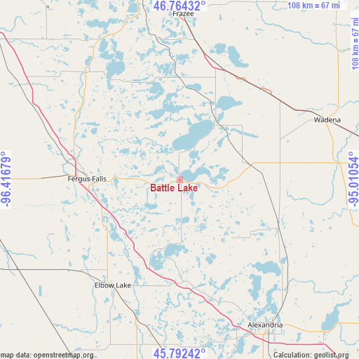
Battle Lake GPS coordinates[2]
46° 16' 49.872" North, 95° 42' 49.176" West
| Map corner | latitude | longitude |
|---|---|---|
| Upper-left | 46.76432°, | -96.41679° |
| Center: | 46.28052°, | -95.71366° |
| Lower-right: | 45.79242°, | -95.01054° |
| Map W x H: | 108.1×108.1 km | = 67.2×67.2mi |
| max Lat: | 71.29058° ⇑4.6% North |
| Battle Lake: | 46.28052° |
| min Lat: | ⇓95.4% South 19.06759° |
| min Long | Battle Lake | max Long |
| -171.73463° | -95.71366° | -66.98998° |
| W 27.1%⇐ | ⇒72.9% E |
Elevation
Elevation of Battle Lake is 414 m = 1358 ft, and this is 119.2 m = 391 ft above average elevation for this country.
| Max E: |
3189 m = 10463 ft | 15.5% |
| Battle Lake | 414 m 1358 ft | |
| Avg. | 294.8 m = 967 ft | |
Min E: |
-60 m = -197 ft | 84.5% |
See also: United States elevation on elevation.city.
Geographical zone
Battle Lake is located in North temperate zone (between Tropic of Cancer and the Arctic Circle). Distance of this North polar circle is 2255.3 km =1401.4 mi to North.| Distance of | km | miles | from Battle Lake |
|---|---|---|---|
| North Pole | 4861.2 | 3020.6 | to North |
| Arctic Circle | 2255.3 | 1401.4 | to North |
| Tropic Cancer | 2540 | 1578.3 | to South |
| Equator | 5145.9 | 3197.5 | to South |


Nearby cities:
15 places around Battle Lake: (largest is in red/bold)
• Alexandria
51 km =31.7 mi,  149°
149°
• Eagle Bend
53.5 km =33.2 mi,  103°
103°
• Elbow Lake
37.7 km =23.4 mi,  212°
212°
• Evansville
30.8 km =19.1 mi,  175°
175°
• Fergus Falls
28 km =17.4 mi,  270°
270°
• Frazee
49.8 km =30.9 mi,  1°
1°
• Henning
21.1 km =13.1 mi,  77°
77°
• Hoffman
50.5 km =31.4 mi,  186°
186°
• New York Mills
37 km =23 mi,  44°
44°
• Ottertail
20.1 km =12.5 mi, 36°
• Parkers Prairie
32.8 km =20.4 mi,  115°
115°
• Pelican Rapids
42.9 km =26.7 mi,  318°
318°
• Perham
36.5 km =22.7 mi,  17°
17°
• Verndale
55.2 km =34.3 mi, 76°
• Wadena
47.8 km =29.7 mi,  67°
67°
Sources, notices
• [Note1] Compared only with cities in United States existing in our database
• [Src1] Map data: © OpenStreetMap contributors (CC-BY-SA)
• [Src2] Other city data from geonames.org with taken over terms of usage.
• [Src3] Geographical zone / Annual Mean Temperature by Robert A. Rohde @ Wikipedia
