Kenyon geodata
Kenyon (Minnesota) is a populated place; located in United States in America/Chicago (GMT-5) time zone. With population of 1,814 people, there are 12490 cities with bigger population in this country. Compared to other cities in United States, 89.5% of cities are located further ↓South; 66.2% of cities are located further →East and 79.8% of cities have lower elevation than Kenyon. Note1


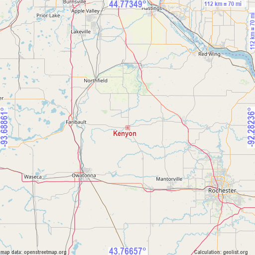
Kenyon GPS coordinates[2]
44° 16' 19.884" North, 92° 59' 7.728" West
| Map corner | latitude | longitude |
|---|---|---|
| Upper-left | 44.77349°, | -93.68861° |
| Center: | 44.27219°, | -92.98548° |
| Lower-right: | 43.76657°, | -92.28236° |
| Map W x H: | 112×112 km | = 69.6×69.6mi |
| max Lat: | 71.29058° ⇑10.5% North |
| Kenyon: | 44.27219° |
| min Lat: | ⇓89.5% South 19.06759° |
| min Long | Kenyon | max Long |
| -171.73463° | -92.98548° | -66.98998° |
| W 33.8%⇐ | ⇒66.2% E |
Elevation
Elevation of Kenyon is 351 m = 1152 ft, and this is 56.2 m = 184 ft above average elevation for this country.
| Max E: |
3189 m = 10463 ft | 20.2% |
| Kenyon | 351 m 1152 ft | |
| Avg. | 294.8 m = 967 ft | |
Min E: |
-60 m = -197 ft | 79.8% |
See also: United States elevation on elevation.city.
Geographical zone
Kenyon is located in North temperate zone (between Tropic of Cancer and the Arctic Circle). Distance of this Northern Tropic circle is 2316.7 km =1439.5 mi to South.| Distance of | km | miles | from Kenyon |
|---|---|---|---|
| North Pole | 5084.5 | 3159.4 | to North |
| Arctic Circle | 2478.6 | 1540.1 | to North |
| Tropic Cancer | 2316.7 | 1439.5 | to South |
| Equator | 4922.6 | 3058.8 | to South |


Nearby cities:
15 places around Kenyon: (largest is in red/bold)
• Cannon Falls
26.9 km =16.7 mi,  13°
13°
• Claremont
25.3 km =15.7 mi,  182°
182°
• Dodge Center
29.1 km =18.1 mi,  158°
158°
• Dundas
24.5 km =15.2 mi,  315°
315°
• Faribault
22.7 km =14.1 mi,  276°
276°
• Goodhue
32.1 km =19.9 mi,  63°
63°
• Mantorville
29.1 km =18.1 mi,  140°
140°
• Medford
23.5 km =14.6 mi,  242°
242°
• Northfield
25 km =15.5 mi,  325°
325°
• Owatonna
28.4 km =17.6 mi,  222°
222°
• Pine Island
28.1 km =17.5 mi,  106°
106°
• Wanamingo
15.9 km =9.9 mi,  77°
77°
• Warsaw
32.6 km =20.3 mi,  265°
265°
• West Concord
14.9 km =9.3 mi,  152°
152°
• Zumbrota
25.3 km =15.7 mi, 84°
Sources, notices
• [Note1] Compared only with cities in United States existing in our database
• [Src1] Map data: © OpenStreetMap contributors (CC-BY-SA)
• [Src2] Other city data from geonames.org with taken over terms of usage.
• [Src3] Geographical zone / Annual Mean Temperature by Robert A. Rohde @ Wikipedia
