Cannon Falls geodata
Cannon Falls (Minnesota) is a populated place; located in United States in America/Chicago (GMT-5) time zone. With population of 4,062 people, there are 8147 cities with bigger population in this country. Compared to other cities in United States, 90.5% of cities are located further ↓South; 66% of cities are located further →East and 62.6% of cities have lower elevation than Cannon Falls. Note1
Administrative division(s):
- Level 1: Minnesota
- Level 2: Goodhue County
- Level 3: City of Cannon Falls


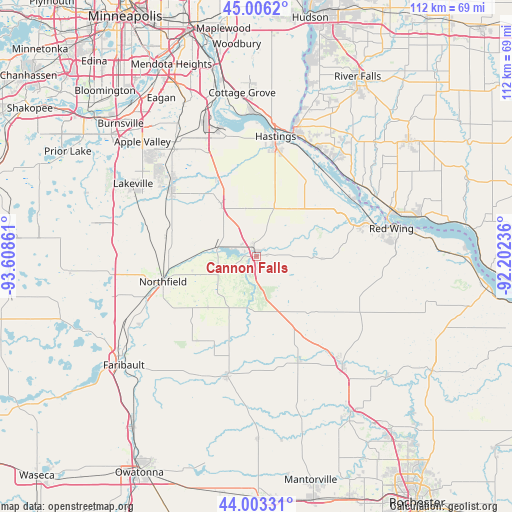
Cannon Falls GPS coordinates[2]
44° 30' 24.876" North, 92° 54' 19.728" West
| Map corner | latitude | longitude |
|---|---|---|
| Upper-left | 45.0062°, | -93.60861° |
| Center: | 44.50691°, | -92.90548° |
| Lower-right: | 44.00331°, | -92.20236° |
| Map W x H: | 111.5×111.5 km | = 69.3×69.3mi |
| max Lat: | 71.29058° ⇑9.5% North |
| Cannon Falls: | 44.50691° |
| min Lat: | ⇓90.5% South 19.06759° |
| min Long | Cannon Falls | max Long |
| -171.73463° | -92.90548° | -66.98998° |
| W 34%⇐ | ⇒66% E |
Elevation
Elevation of Cannon Falls is 251 m = 823 ft, and this is 43.8 m = 144 ft below average elevation for this country.
| Max E: |
3189 m = 10463 ft | 37.4% |
| Avg. | 294.8 m = 967 ft | |
| Cannon Falls | 251 m = 823 ft | |
Min E: |
-60 m = -197 ft | 62.6% |
See also: United States elevation on elevation.city.
Geographical zone
Cannon Falls is located in North temperate zone (between Tropic of Cancer and the Arctic Circle). Distance of this Northern Tropic circle is 2342.8 km =1455.7 mi to South.| Distance of | km | miles | from Cannon Falls |
|---|---|---|---|
| North Pole | 5058.4 | 3143.1 | to North |
| Arctic Circle | 2452.5 | 1523.9 | to North |
| Tropic Cancer | 2342.8 | 1455.7 | to South |
| Equator | 4948.7 | 3075 | to South |


Nearby cities:
15 places around Cannon Falls: (largest is in red/bold)
• Dundas
25 km =15.5 mi,  249°
249°
• Elko
34 km =21.1 mi,  280°
280°
• Elko New Market
34 km =21.1 mi, 280°
• Farmington
24 km =14.9 mi,  308°
308°
• Goodhue
25.3 km =15.7 mi,  117°
117°
• Hampton
13.8 km =8.6 mi,  326°
326°
• Hastings
26.6 km =16.5 mi,  9°
9°
• Kenyon
26.9 km =16.7 mi,  193°
193°
• Lakeville
31.1 km =19.3 mi,  300°
300°
• Northfield
21 km =13 mi,  255°
255°
• Prescott
28.1 km =17.5 mi,  16°
16°
• Red Wing
30.1 km =18.7 mi,  78°
78°
• Rosemount
31.2 km =19.4 mi, 326°
• Wanamingo
24.3 km =15.1 mi,  157°
157°
• Zumbrota
30.2 km =18.8 mi,  141°
141°
Sources, notices
• [Note1] Compared only with cities in United States existing in our database
• [Src1] Map data: © OpenStreetMap contributors (CC-BY-SA)
• [Src2] Other city data from geonames.org with taken over terms of usage.
• [Src3] Geographical zone / Annual Mean Temperature by Robert A. Rohde @ Wikipedia
