Zumbrota geodata
Zumbrota (Minnesota) is a populated place; located in United States in America/Chicago (GMT-5) time zone. With population of 3,365 people, there are 9048 cities with bigger population in this country. Compared to other cities in United States, 89.6% of cities are located further ↓South; 65.6% of cities are located further →East and 72.6% of cities have lower elevation than Zumbrota. Note1


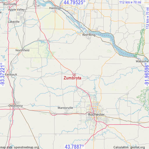
Zumbrota GPS coordinates[2]
44° 17' 38.868" North, 92° 40' 8.688" West
| Map corner | latitude | longitude |
|---|---|---|
| Upper-left | 44.79525°, | -93.37221° |
| Center: | 44.29413°, | -92.66908° |
| Lower-right: | 43.7887°, | -91.96596° |
| Map W x H: | 111.9×111.9 km | = 69.5×69.5mi |
| max Lat: | 71.29058° ⇑10.4% North |
| Zumbrota: | 44.29413° |
| min Lat: | ⇓89.6% South 19.06759° |
| min Long | Zumbrota | max Long |
| -171.73463° | -92.66908° | -66.98998° |
| W 34.4%⇐ | ⇒65.6% E |
Elevation
Elevation of Zumbrota is 299 m = 981 ft, and this is 4.2 m = 14 ft above average elevation for this country.
| Max E: |
3189 m = 10463 ft | 27.4% |
| Zumbrota | 299 m 981 ft | |
| Avg. | 294.8 m = 967 ft | |
Min E: |
-60 m = -197 ft | 72.6% |
See also: United States elevation on elevation.city.
Geographical zone
Zumbrota is located in North temperate zone (between Tropic of Cancer and the Arctic Circle). Distance of this Northern Tropic circle is 2319.1 km =1441 mi to South.| Distance of | km | miles | from Zumbrota |
|---|---|---|---|
| North Pole | 5082 | 3157.8 | to North |
| Arctic Circle | 2476.1 | 1538.6 | to North |
| Tropic Cancer | 2319.1 | 1441 | to South |
| Equator | 4925 | 3060.3 | to South |


Nearby cities:
15 places around Zumbrota: (largest is in red/bold)
• Byron
29.1 km =18.1 mi,  176°
176°
• Cannon Falls
30.2 km =18.8 mi,  321°
321°
• Dodge Center
33.1 km =20.6 mi,  206°
206°
• Goodhue
12.4 km =7.7 mi,  16°
16°
• Kasson
30.1 km =18.7 mi,  192°
192°
• Kenyon
25.3 km =15.7 mi,  264°
264°
• Lake City
36.3 km =22.6 mi,  61°
61°
• Mantorville
26 km =16.2 mi,  195°
195°
• Mazeppa
10.2 km =6.3 mi,  103°
103°
• Oronoco
17.8 km =11.1 mi,  143°
143°
• Pine Island
10.5 km =6.5 mi,  170°
170°
• Red Wing
31.7 km =19.7 mi, 19°
• Rochester
34.2 km =21.3 mi,  152°
152°
• Wanamingo
9.7 km =6 mi,  276°
276°
• West Concord
24.1 km =15 mi,  229°
229°
Sources, notices
• [Note1] Compared only with cities in United States existing in our database
• [Src1] Map data: © OpenStreetMap contributors (CC-BY-SA)
• [Src2] Other city data from geonames.org with taken over terms of usage.
• [Src3] Geographical zone / Annual Mean Temperature by Robert A. Rohde @ Wikipedia
