Northfield geodata
Northfield (Minnesota) is a populated place; located in United States in America/Chicago (GMT-5) time zone. With population of 20,380 people, there are 2464 cities with bigger population in this country. Compared to other cities in United States, 90.3% of cities are located further ↓South; 66.6% of cities are located further →East and 68% of cities have lower elevation than Northfield. Note1


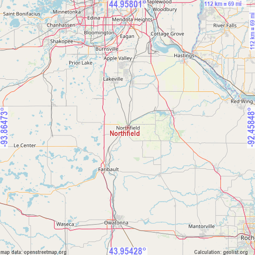
Northfield GPS coordinates[2]
44° 27' 29.88" North, 93° 9' 41.76" West
| Map corner | latitude | longitude |
|---|---|---|
| Upper-left | 44.95801°, | -93.86473° |
| Center: | 44.4583°, | -93.1616° |
| Lower-right: | 43.95428°, | -92.45848° |
| Map W x H: | 111.6×111.6 km | = 69.3×69.3mi |
| max Lat: | 71.29058° ⇑9.7% North |
| Northfield: | 44.4583° |
| min Lat: | ⇓90.3% South 19.06759° |
| min Long | Northfield | max Long |
| -171.73463° | -93.1616° | -66.98998° |
| W 33.4%⇐ | ⇒66.6% E |
Elevation
Elevation of Northfield is 276 m = 906 ft, and this is 18.8 m = 62 ft below average elevation for this country.
| Max E: |
3189 m = 10463 ft | 32% |
| Avg. | 294.8 m = 967 ft | |
| Northfield | 276 m = 906 ft | |
Min E: |
-60 m = -197 ft | 68% |
See also: United States elevation on elevation.city.
Geographical zone
Northfield is located in North temperate zone (between Tropic of Cancer and the Arctic Circle). Distance of this Northern Tropic circle is 2337.4 km =1452.4 mi to South.| Distance of | km | miles | from Northfield |
|---|---|---|---|
| North Pole | 5063.8 | 3146.5 | to North |
| Arctic Circle | 2457.9 | 1527.3 | to North |
| Tropic Cancer | 2337.4 | 1452.4 | to South |
| Equator | 4943.3 | 3071.6 | to South |


Nearby cities:
15 places around Northfield: (largest is in red/bold)
• Apple Valley
30.7 km =19.1 mi,  351°
351°
• Cannon Falls
21 km =13 mi,  75°
75°
• Dundas
4.5 km =2.8 mi,  224°
224°
• Elko
17.7 km =11 mi,  312°
312°
• Elko New Market
17.7 km =11 mi, 312°
• Faribault
20.1 km =12.5 mi,  205°
205°
• Farmington
20.3 km =12.6 mi,  4°
4°
• Hampton
21.1 km =13.1 mi,  36°
36°
• Kenyon
25 km =15.5 mi,  145°
145°
• Lakeville
22.2 km =13.8 mi,  343°
343°
• Lonsdale
21.3 km =13.2 mi,  276°
276°
• Medford
32.3 km =20.1 mi,  192°
192°
• New Market
19.9 km =12.4 mi, 309°
• Rosemount
31.4 km =19.5 mi,  5°
5°
• Warsaw
29.7 km =18.5 mi, 218°
Sources, notices
• [Note1] Compared only with cities in United States existing in our database
• [Src1] Map data: © OpenStreetMap contributors (CC-BY-SA)
• [Src2] Other city data from geonames.org with taken over terms of usage.
• [Src3] Geographical zone / Annual Mean Temperature by Robert A. Rohde @ Wikipedia
