Mahnomen geodata
Mahnomen (Minnesota) is a seat of a second-order administrative division; located in United States in America/Chicago (GMT-5) time zone. With population of 1,222 people, there are 15001 cities with bigger population in this country. Compared to other cities in United States, 97.2% of cities are located further ↓South; 73.4% of cities are located further →East and 81.3% of cities have lower elevation than Mahnomen. Note1


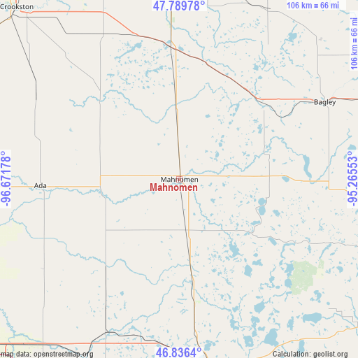
Mahnomen GPS coordinates[2]
47° 18' 54.864" North, 95° 58' 7.14" West
| Map corner | latitude | longitude |
|---|---|---|
| Upper-left | 47.78978°, | -96.67178° |
| Center: | 47.31524°, | -95.96865° |
| Lower-right: | 46.8364°, | -95.26553° |
| Map W x H: | 106×106 km | = 65.9×65.9mi |
| max Lat: | 71.29058° ⇑2.8% North |
| Mahnomen: | 47.31524° |
| min Lat: | ⇓97.2% South 19.06759° |
| min Long | Mahnomen | max Long |
| -171.73463° | -95.96865° | -66.98998° |
| W 26.6%⇐ | ⇒73.4% E |
Elevation
Elevation of Mahnomen is 368 m = 1207 ft, and this is 73.2 m = 240 ft above average elevation for this country.
| Max E: |
3189 m = 10463 ft | 18.7% |
| Mahnomen | 368 m 1207 ft | |
| Avg. | 294.8 m = 967 ft | |
Min E: |
-60 m = -197 ft | 81.3% |
See also: United States elevation on elevation.city.
Geographical zone
Mahnomen is located in North temperate zone (between Tropic of Cancer and the Arctic Circle). Distance of this North polar circle is 2140.2 km =1329.9 mi to North.| Distance of | km | miles | from Mahnomen |
|---|---|---|---|
| North Pole | 4746.1 | 2949.1 | to North |
| Arctic Circle | 2140.2 | 1329.9 | to North |
| Tropic Cancer | 2655 | 1649.7 | to South |
| Equator | 5261 | 3269 | to South |


Nearby cities:
15 places around Mahnomen: (largest is in red/bold)
• Ada
41.3 km =25.7 mi,  267°
267°
• Audubon
50.3 km =31.3 mi,  181°
181°
• Bagley
48.7 km =30.3 mi,  61°
61°
• Clearbrook
58.2 km =36.2 mi,  43°
43°
• Detroit Lakes
56.2 km =34.9 mi,  170°
170°
• Fertile
34 km =21.1 mi,  316°
316°
• Fosston
33.3 km =20.7 mi,  29°
29°
• Halstad
64.9 km =40.3 mi, 273°
• Hawley
55 km =34.2 mi,  208°
208°
• Lake Park
48.6 km =30.2 mi,  191°
191°
• McIntosh
36.3 km =22.6 mi,  9°
9°
• Naytahwaush
26.5 km =16.5 mi,  102°
102°
• Twin Valley
22.7 km =14.1 mi,  254°
254°
• Ulen
34.2 km =21.3 mi,  219°
219°
• White Earth
26.1 km =16.2 mi,  158°
158°
Sources, notices
• [Note1] Compared only with cities in United States existing in our database
• [Src1] Map data: © OpenStreetMap contributors (CC-BY-SA)
• [Src2] Other city data from geonames.org with taken over terms of usage.
• [Src3] Geographical zone / Annual Mean Temperature by Robert A. Rohde @ Wikipedia
