White Earth geodata
White Earth (Minnesota) is a populated place; located in United States in America/Chicago (GMT-5) time zone. With population of 580 people, there are 19917 cities with bigger population in this country. Compared to other cities in United States, 96.8% of cities are located further ↓South; 73.1% of cities are located further →East and 86.8% of cities have lower elevation than White Earth. Note1
Administrative division(s):
- Level 1: Minnesota
- Level 2: Becker County
- Level 3: Township of White Earth


White Earth GPS coordinates[2]
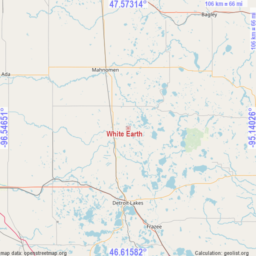
47° 5' 47.868" North, 95° 50' 36.168" West
| Map corner | latitude | longitude |
|---|---|---|
| Upper-left | 47.57314°, | -96.54651° |
| Center: | 47.09663°, | -95.84338° |
| Lower-right: | 46.61582°, | -95.14026° |
| Map W x H: | 106.4×106.4 km | = 66.1×66.1mi |
| max Lat: | 71.29058° ⇑3.2% North |
| White Earth: | 47.09663° |
| min Lat: | ⇓96.8% South 19.06759° |
| min Long | White Earth | max Long |
| -171.73463° | -95.84338° | -66.98998° |
| W 26.9%⇐ | ⇒73.1% E |
Elevation
Elevation of White Earth is 464 m = 1522 ft, and this is 169.2 m = 555 ft above average elevation for this country.
| Max E: |
3189 m = 10463 ft | 13.2% |
| White Earth | 464 m 1522 ft | |
| Avg. | 294.8 m = 967 ft | |
Min E: |
-60 m = -197 ft | 86.8% |
See also: United States elevation on elevation.city.
Geographical zone
White Earth is located in North temperate zone (between Tropic of Cancer and the Arctic Circle). Distance of this North polar circle is 2164.5 km =1345 mi to North.| Distance of | km | miles | from White Earth |
|---|---|---|---|
| North Pole | 4770.4 | 2964.2 | to North |
| Arctic Circle | 2164.5 | 1345 | to North |
| Tropic Cancer | 2630.7 | 1634.6 | to South |
| Equator | 5236.7 | 3253.9 | to South |


Nearby cities:
15 places around White Earth: (largest is in red/bold)
• Ada
55.6 km =34.5 mi,  293°
293°
• Audubon
28 km =17.4 mi,  202°
202°
• Bagley
58 km =36 mi,  35°
35°
• Detroit Lakes
31.1 km =19.3 mi,  180°
180°
• Fertile
58.9 km =36.6 mi,  326°
326°
• Fosston
53.8 km =33.4 mi,  7°
7°
• Frazee
42.4 km =26.3 mi,  165°
165°
• Hawley
43.2 km =26.8 mi,  236°
236°
• Lake Park
30.2 km =18.8 mi,  219°
219°
• Mahnomen
26.1 km =16.2 mi,  338°
338°
• McIntosh
60.2 km =37.4 mi,  356°
356°
• Naytahwaush
24.7 km =15.3 mi, 41°
• Perham
59.5 km =37 mi,  159°
159°
• Twin Valley
36.3 km =22.6 mi,  300°
300°
• Ulen
31.5 km =19.6 mi,  266°
266°
Sources, notices
• [Note1] Compared only with cities in United States existing in our database
• [Src1] Map data: © OpenStreetMap contributors (CC-BY-SA)
• [Src2] Other city data from geonames.org with taken over terms of usage.
• [Src3] Geographical zone / Annual Mean Temperature by Robert A. Rohde @ Wikipedia
