Fertile geodata
Fertile (Minnesota) is a populated place; located in United States in America/Chicago (GMT-5) time zone. With population of 841 people, there are 17445 cities with bigger population in this country. Compared to other cities in United States, 97.8% of cities are located further ↓South; 74% of cities are located further →East and 79.3% of cities have lower elevation than Fertile. Note1


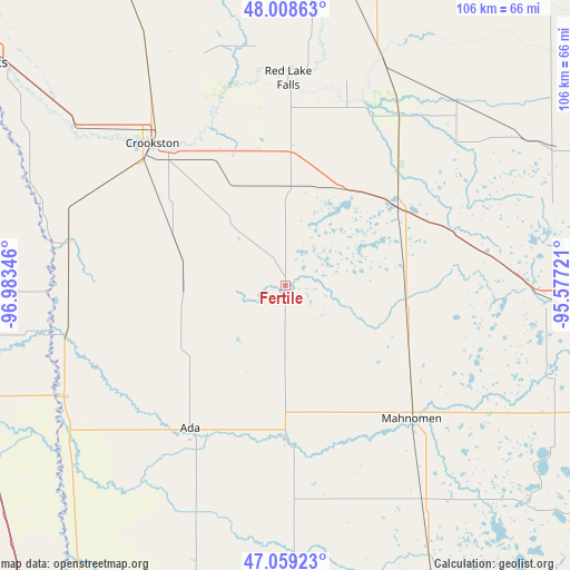
Fertile GPS coordinates[2]
47° 32' 9.888" North, 96° 16' 49.188" West
| Map corner | latitude | longitude |
|---|---|---|
| Upper-left | 48.00863°, | -96.98346° |
| Center: | 47.53608°, | -96.28033° |
| Lower-right: | 47.05923°, | -95.57721° |
| Map W x H: | 105.6×105.6 km | = 65.6×65.6mi |
| max Lat: | 71.29058° ⇑2.2% North |
| Fertile: | 47.53608° |
| min Lat: | ⇓97.8% South 19.06759° |
| min Long | Fertile | max Long |
| -171.73463° | -96.28033° | -66.98998° |
| W 26%⇐ | ⇒74% E |
Elevation
Elevation of Fertile is 347 m = 1138 ft, and this is 52.2 m = 171 ft above average elevation for this country.
| Max E: |
3189 m = 10463 ft | 20.7% |
| Fertile | 347 m 1138 ft | |
| Avg. | 294.8 m = 967 ft | |
Min E: |
-60 m = -197 ft | 79.3% |
See also: United States elevation on elevation.city.
Geographical zone
Fertile is located in North temperate zone (between Tropic of Cancer and the Arctic Circle). Distance of this North polar circle is 2115.7 km =1314.6 mi to North.| Distance of | km | miles | from Fertile |
|---|---|---|---|
| North Pole | 4721.5 | 2933.8 | to North |
| Arctic Circle | 2115.7 | 1314.6 | to North |
| Tropic Cancer | 2679.6 | 1665 | to South |
| Equator | 5285.5 | 3284.3 | to South |


Nearby cities:
15 places around Fertile: (largest is in red/bold)
• Ada
31.7 km =19.7 mi,  213°
213°
• Bagley
66.2 km =41.1 mi,  91°
91°
• Clearbrook
66 km =41 mi,  74°
74°
• Crookston
36.1 km =22.4 mi,  317°
317°
• Fosston
39.9 km =24.8 mi,  83°
83°
• Halstad
46.1 km =28.6 mi,  243°
243°
• Hillsboro
60.6 km =37.7 mi,  255°
255°
• Mahnomen
34 km =21.1 mi,  136°
136°
• McIntosh
31.6 km =19.6 mi, 69°
• Naytahwaush
57.9 km =36 mi,  121°
121°
• Red Lake Falls
38.5 km =23.9 mi,  0°
0°
• Thief River Falls
65.3 km =40.6 mi,  6°
6°
• Twin Valley
30.7 km =19.1 mi,  176°
176°
• Ulen
50.9 km =31.6 mi, 178°
• White Earth
58.9 km =36.6 mi,  146°
146°
Sources, notices
• [Note1] Compared only with cities in United States existing in our database
• [Src1] Map data: © OpenStreetMap contributors (CC-BY-SA)
• [Src2] Other city data from geonames.org with taken over terms of usage.
• [Src3] Geographical zone / Annual Mean Temperature by Robert A. Rohde @ Wikipedia
