Halstad geodata
Halstad (Minnesota) is a populated place; located in United States in America/Chicago (GMT-5) time zone. With population of 575 people, there are 19968 cities with bigger population in this country. Compared to other cities in United States, 97.3% of cities are located further ↓South; 75.3% of cities are located further →East and 65.6% of cities have lower elevation than Halstad. Note1


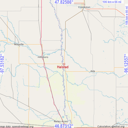
Halstad GPS coordinates[2]
47° 21' 5.904" North, 96° 49' 43.284" West
| Map corner | latitude | longitude |
|---|---|---|
| Upper-left | 47.82586°, | -97.53182° |
| Center: | 47.35164°, | -96.82869° |
| Lower-right: | 46.87312°, | -96.12557° |
| Map W x H: | 105.9×105.9 km | = 65.8×65.8mi |
| max Lat: | 71.29058° ⇑2.7% North |
| Halstad: | 47.35164° |
| min Lat: | ⇓97.3% South 19.06759° |
| min Long | Halstad | max Long |
| -171.73463° | -96.82869° | -66.98998° |
| W 24.7%⇐ | ⇒75.3% E |
Elevation
Elevation of Halstad is 265 m = 869 ft, and this is 29.8 m = 98 ft below average elevation for this country.
| Max E: |
3189 m = 10463 ft | 34.4% |
| Avg. | 294.8 m = 967 ft | |
| Halstad | 265 m = 869 ft | |
Min E: |
-60 m = -197 ft | 65.6% |
See also: United States elevation on elevation.city.
Geographical zone
Halstad is located in North temperate zone (between Tropic of Cancer and the Arctic Circle). Distance of this North polar circle is 2136.2 km =1327.4 mi to North.| Distance of | km | miles | from Halstad |
|---|---|---|---|
| North Pole | 4742.1 | 2946.6 | to North |
| Arctic Circle | 2136.2 | 1327.4 | to North |
| Tropic Cancer | 2659.1 | 1652.3 | to South |
| Equator | 5265 | 3271.5 | to South |


Nearby cities:
15 places around Halstad: (largest is in red/bold)
• Ada
24.3 km =15.1 mi,  103°
103°
• Crookston
49.8 km =30.9 mi,  19°
19°
• Fargo
52.8 km =32.8 mi,  176°
176°
• Fertile
46.1 km =28.6 mi,  63°
63°
• Harwood
41.6 km =25.8 mi,  185°
185°
• Hillsboro
18.5 km =11.5 mi,  288°
288°
• Mayville
40.7 km =25.3 mi, 293°
• Moorhead
53.3 km =33.1 mi, 175°
• Oakport
46.8 km =29.1 mi, 175°
• Portland
43.9 km =27.3 mi, 291°
• Reiles Acres
47.7 km =29.6 mi, 183°
• Thompson
51.4 km =31.9 mi,  335°
335°
• Twin Valley
44.1 km =27.4 mi, 103°
• Ulen
52.6 km =32.7 mi,  125°
125°
• West Fargo
53.3 km =33.1 mi, 185°
Sources, notices
• [Note1] Compared only with cities in United States existing in our database
• [Src1] Map data: © OpenStreetMap contributors (CC-BY-SA)
• [Src2] Other city data from geonames.org with taken over terms of usage.
• [Src3] Geographical zone / Annual Mean Temperature by Robert A. Rohde @ Wikipedia
