Fosston geodata
Fosston (Minnesota) is a populated place; located in United States in America/Chicago (GMT-5) time zone. With population of 1,498 people, there are 13663 cities with bigger population in this country. Compared to other cities in United States, 97.8% of cities are located further ↓South; 72.9% of cities are located further →East and 83.2% of cities have lower elevation than Fosston. Note1


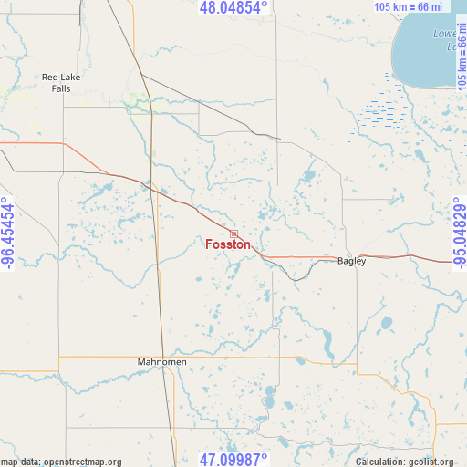
Fosston GPS coordinates[2]
47° 34' 34.86" North, 95° 45' 5.076" West
| Map corner | latitude | longitude |
|---|---|---|
| Upper-left | 48.04854°, | -96.45454° |
| Center: | 47.57635°, | -95.75141° |
| Lower-right: | 47.09987°, | -95.04829° |
| Map W x H: | 105.5×105.5 km | = 65.6×65.6mi |
| max Lat: | 71.29058° ⇑2.2% North |
| Fosston: | 47.57635° |
| min Lat: | ⇓97.8% South 19.06759° |
| min Long | Fosston | max Long |
| -171.73463° | -95.75141° | -66.98998° |
| W 27.1%⇐ | ⇒72.9% E |
Elevation
Elevation of Fosston is 393 m = 1289 ft, and this is 98.2 m = 322 ft above average elevation for this country.
| Max E: |
3189 m = 10463 ft | 16.8% |
| Fosston | 393 m 1289 ft | |
| Avg. | 294.8 m = 967 ft | |
Min E: |
-60 m = -197 ft | 83.2% |
See also: United States elevation on elevation.city.
Geographical zone
Fosston is located in North temperate zone (between Tropic of Cancer and the Arctic Circle). Distance of this North polar circle is 2111.2 km =1311.8 mi to North.| Distance of | km | miles | from Fosston |
|---|---|---|---|
| North Pole | 4717.1 | 2931.1 | to North |
| Arctic Circle | 2111.2 | 1311.8 | to North |
| Tropic Cancer | 2684.1 | 1667.8 | to South |
| Equator | 5290 | 3287.1 | to South |


Nearby cities:
15 places around Fosston: (largest is in red/bold)
• Ada
65.2 km =40.5 mi,  241°
241°
• Bagley
27.2 km =16.9 mi,  102°
102°
• Bemidji
66.4 km =41.3 mi, 99°
• Clearbrook
27.2 km =16.9 mi,  61°
61°
• Crookston
67.8 km =42.1 mi,  288°
288°
• Fertile
39.9 km =24.8 mi,  263°
263°
• Little Rock
57.9 km =36 mi, 55°
• Mahnomen
33.3 km =20.7 mi,  209°
209°
• McIntosh
12.2 km =7.6 mi,  303°
303°
• Naytahwaush
36.1 km =22.4 mi,  164°
164°
• Red Lake
64.3 km =40 mi, 58°
• Red Lake Falls
51.8 km =32.2 mi,  311°
311°
• Twin Valley
51.9 km =32.2 mi,  227°
227°
• Ulen
67.3 km =41.8 mi, 214°
• White Earth
53.8 km =33.4 mi,  187°
187°
Sources, notices
• [Note1] Compared only with cities in United States existing in our database
• [Src1] Map data: © OpenStreetMap contributors (CC-BY-SA)
• [Src2] Other city data from geonames.org with taken over terms of usage.
• [Src3] Geographical zone / Annual Mean Temperature by Robert A. Rohde @ Wikipedia
