Red Wing geodata
Red Wing (Minnesota) is a seat of a second-order administrative division; located in United States in America/Chicago (GMT-5) time zone. With population of 16,445 people, there are 2985 cities with bigger population in this country. Compared to other cities in United States, 90.7% of cities are located further ↓South; 65.3% of cities are located further →East and 56.1% of cities have lower elevation than Red Wing. Note1


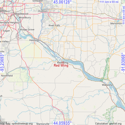
Red Wing GPS coordinates[2]
44° 33' 44.892" North, 92° 32' 1.68" West
| Map corner | latitude | longitude |
|---|---|---|
| Upper-left | 45.06128°, | -93.23693° |
| Center: | 44.56247°, | -92.5338° |
| Lower-right: | 44.05935°, | -91.83068° |
| Map W x H: | 111.4×111.4 km | = 69.2×69.2mi |
| max Lat: | 71.29058° ⇑9.3% North |
| Red Wing: | 44.56247° |
| min Lat: | ⇓90.7% South 19.06759° |
| min Long | Red Wing | max Long |
| -171.73463° | -92.5338° | -66.98998° |
| W 34.7%⇐ | ⇒65.3% E |
Elevation
Elevation of Red Wing is 223 m = 732 ft, and this is 71.8 m = 236 ft below average elevation for this country.
| Max E: |
3189 m = 10463 ft | 43.9% |
| Avg. | 294.8 m = 967 ft | |
| Red Wing | 223 m = 732 ft | |
Min E: |
-60 m = -197 ft | 56.1% |
See also: United States elevation on elevation.city.
Geographical zone
Red Wing is located in North temperate zone (between Tropic of Cancer and the Arctic Circle). Distance of this Northern Tropic circle is 2349 km =1459.6 mi to South.| Distance of | km | miles | from Red Wing |
|---|---|---|---|
| North Pole | 5052.2 | 3139.3 | to North |
| Arctic Circle | 2446.3 | 1520.1 | to North |
| Tropic Cancer | 2349 | 1459.6 | to South |
| Equator | 4954.9 | 3078.8 | to South |


Nearby cities:
15 places around Red Wing: (largest is in red/bold)
• Cannon Falls
30.1 km =18.7 mi,  258°
258°
• El Paso
27.5 km =17.1 mi,  33°
33°
• Ellsworth
19.2 km =11.9 mi,  11°
11°
• Goodhue
19.4 km =12.1 mi,  201°
201°
• Hampton
37.5 km =23.3 mi,  278°
278°
• Hastings
32.2 km =20 mi,  308°
308°
• Lake City
24.5 km =15.2 mi,  120°
120°
• Mazeppa
32.2 km =20 mi,  181°
181°
• Pepin
33.4 km =20.8 mi,  113°
113°
• Plum City
28 km =17.4 mi,  74°
74°
• Prescott
29.7 km =18.5 mi, 314°
• River Falls
34 km =21.1 mi,  347°
347°
• Spring Valley
39.1 km =24.3 mi,  36°
36°
• Wanamingo
35.2 km =21.9 mi,  215°
215°
• Zumbrota
31.7 km =19.7 mi, 199°
Sources, notices
• [Note1] Compared only with cities in United States existing in our database
• [Src1] Map data: © OpenStreetMap contributors (CC-BY-SA)
• [Src2] Other city data from geonames.org with taken over terms of usage.
• [Src3] Geographical zone / Annual Mean Temperature by Robert A. Rohde @ Wikipedia
