Lakeville geodata
Lakeville (Minnesota) is a populated place; located in United States in America/Chicago (GMT-5) time zone. With population of 60,633 people, there are 729 cities with bigger population in this country. Compared to other cities in United States, 91.1% of cities are located further ↓South; 66.8% of cities are located further →East and 72% of cities have lower elevation than Lakeville. Note1


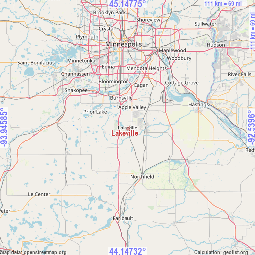
Lakeville GPS coordinates[2]
44° 38' 58.884" North, 93° 14' 33.792" West
| Map corner | latitude | longitude |
|---|---|---|
| Upper-left | 45.14775°, | -93.94585° |
| Center: | 44.64969°, | -93.24272° |
| Lower-right: | 44.14732°, | -92.5396° |
| Map W x H: | 111.2×111.2 km | = 69.1×69.1mi |
| max Lat: | 71.29058° ⇑8.9% North |
| Lakeville: | 44.64969° |
| min Lat: | ⇓91.1% South 19.06759° |
| min Long | Lakeville | max Long |
| -171.73463° | -93.24272° | -66.98998° |
| W 33.2%⇐ | ⇒66.8% E |
Elevation
Elevation of Lakeville is 296 m = 971 ft, and this is 1.2 m = 4 ft above average elevation for this country.
| Max E: |
3189 m = 10463 ft | 28% |
| Lakeville | 296 m 971 ft | |
| Avg. | 294.8 m = 967 ft | |
Min E: |
-60 m = -197 ft | 72% |
See also: Lakeville elevation on elevation.city.
Geographical zone
Lakeville is located in North temperate zone (between Tropic of Cancer and the Arctic Circle). Distance of this Northern Tropic circle is 2358.7 km =1465.6 mi to South.| Distance of | km | miles | from Lakeville |
|---|---|---|---|
| North Pole | 5042.5 | 3133.3 | to North |
| Arctic Circle | 2436.6 | 1514 | to North |
| Tropic Cancer | 2358.7 | 1465.6 | to South |
| Equator | 4964.6 | 3084.9 | to South |


Nearby cities:
15 places around Lakeville: (largest is in red/bold)
• Apple Valley
9.4 km =5.8 mi,  12°
12°
• Bloomington
21.7 km =13.5 mi,  348°
348°
• Burnsville
13.4 km =8.3 mi, 348°
• Dundas
24.7 km =15.3 mi,  172°
172°
• Eagan
18.2 km =11.3 mi,  19°
19°
• Elko
11.6 km =7.2 mi,  215°
215°
• Elko New Market
11.6 km =7.2 mi, 215°
• Farmington
7.9 km =4.9 mi,  97°
97°
• Hampton
19.5 km =12.1 mi, 102°
• Lonsdale
23.9 km =14.9 mi, 218°
• New Market
12.2 km =7.6 mi,  225°
225°
• Northfield
22.2 km =13.8 mi,  163°
163°
• Prior Lake
15.9 km =9.9 mi,  296°
296°
• Rosemount
13.6 km =8.5 mi,  42°
42°
• Savage
16.2 km =10.1 mi,  332°
332°
Sources, notices
• [Note1] Compared only with cities in United States existing in our database
• [Src1] Map data: © OpenStreetMap contributors (CC-BY-SA)
• [Src2] Other city data from geonames.org with taken over terms of usage.
• [Src3] Geographical zone / Annual Mean Temperature by Robert A. Rohde @ Wikipedia
