Larimore geodata
Larimore (North Dakota) is a populated place; located in United States in America/Chicago (GMT-5) time zone. With population of 1,313 people, there are 14535 cities with bigger population in this country. Compared to other cities in United States, 98.5% of cities are located further ↓South; 77.5% of cities are located further →East and 79.3% of cities have lower elevation than Larimore. Note1
Administrative division(s):
- Level 1: North Dakota
- Level 2: Grand Forks County
- Level 3: City of Larimore


Larimore GPS coordinates[2]
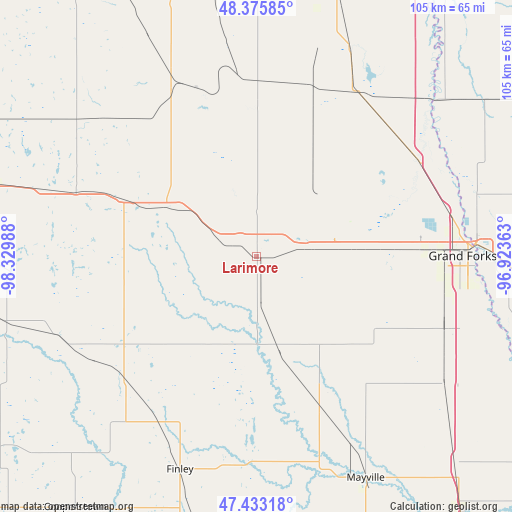
47° 54' 23.976" North, 97° 37' 36.3" West
| Map corner | latitude | longitude |
|---|---|---|
| Upper-left | 48.37585°, | -98.32988° |
| Center: | 47.90666°, | -97.62675° |
| Lower-right: | 47.43318°, | -96.92363° |
| Map W x H: | 104.8×104.8 km | = 65.1×65.1mi |
| max Lat: | 71.29058° ⇑1.5% North |
| Larimore: | 47.90666° |
| min Lat: | ⇓98.5% South 19.06759° |
| min Long | Larimore | max Long |
| -171.73463° | -97.62675° | -66.98998° |
| W 22.5%⇐ | ⇒77.5% E |
Elevation
Elevation of Larimore is 347 m = 1138 ft, and this is 52.2 m = 171 ft above average elevation for this country.
| Max E: |
3189 m = 10463 ft | 20.7% |
| Larimore | 347 m 1138 ft | |
| Avg. | 294.8 m = 967 ft | |
Min E: |
-60 m = -197 ft | 79.3% |
See also: United States elevation on elevation.city.
Geographical zone
Larimore is located in North temperate zone (between Tropic of Cancer and the Arctic Circle). Distance of this North polar circle is 2074.5 km =1289 mi to North.| Distance of | km | miles | from Larimore |
|---|---|---|---|
| North Pole | 4680.3 | 2908.2 | to North |
| Arctic Circle | 2074.5 | 1289 | to North |
| Tropic Cancer | 2720.8 | 1690.6 | to South |
| Equator | 5326.7 | 3309.9 | to South |


Nearby cities:
15 places around Larimore: (largest is in red/bold)
• Cooperstown
63.5 km =39.5 mi,  215°
215°
• East Grand Forks
45 km =28 mi,  86°
86°
• Finley
46.4 km =28.8 mi,  199°
199°
• Grafton
58.5 km =36.4 mi,  15°
15°
• Grand Forks
44.3 km =27.5 mi, 87°
• Grand Forks Air Force Base
18.7 km =11.6 mi,  73°
73°
• Hatton
32.4 km =20.1 mi,  156°
156°
• Hillsboro
70.1 km =43.6 mi,  142°
142°
• Lakota
54.9 km =34.1 mi,  285°
285°
• Mayville
50.8 km =31.6 mi,  153°
153°
• Minto
46.8 km =29.1 mi, 23°
• Northwood
19.7 km =12.2 mi,  166°
166°
• Park River
55.4 km =34.4 mi,  351°
351°
• Portland
49.3 km =30.6 mi, 157°
• Thompson
41.3 km =25.7 mi,  110°
110°
Sources, notices
• [Note1] Compared only with cities in United States existing in our database
• [Src1] Map data: © OpenStreetMap contributors (CC-BY-SA)
• [Src2] Other city data from geonames.org with taken over terms of usage.
• [Src3] Geographical zone / Annual Mean Temperature by Robert A. Rohde @ Wikipedia
