Northwood geodata
Northwood (North Dakota) is a populated place; located in United States in America/Chicago (GMT-5) time zone. With population of 927 people, there are 16817 cities with bigger population in this country. Compared to other cities in United States, 98.1% of cities are located further ↓South; 77.3% of cities are located further →East and 78.5% of cities have lower elevation than Northwood. Note1
Administrative division(s):
- Level 1: North Dakota
- Level 2: Grand Forks County
- Level 3: City of Northwood


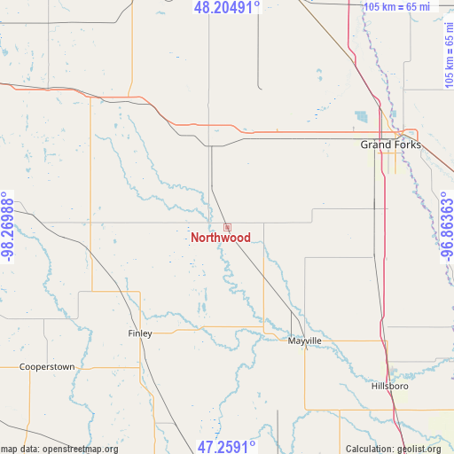
Northwood GPS coordinates[2]
47° 44' 2.94" North, 97° 34' 0.3" West
| Map corner | latitude | longitude |
|---|---|---|
| Upper-left | 48.20491°, | -98.26988° |
| Center: | 47.73415°, | -97.56675° |
| Lower-right: | 47.2591°, | -96.86363° |
| Map W x H: | 105.2×105.2 km | = 65.4×65.4mi |
| max Lat: | 71.29058° ⇑1.9% North |
| Northwood: | 47.73415° |
| min Lat: | ⇓98.1% South 19.06759° |
| min Long | Northwood | max Long |
| -171.73463° | -97.56675° | -66.98998° |
| W 22.7%⇐ | ⇒77.3% E |
Elevation
Elevation of Northwood is 340 m = 1115 ft, and this is 45.2 m = 148 ft above average elevation for this country.
| Max E: |
3189 m = 10463 ft | 21.5% |
| Northwood | 340 m 1115 ft | |
| Avg. | 294.8 m = 967 ft | |
Min E: |
-60 m = -197 ft | 78.5% |
See also: United States elevation on elevation.city.
Geographical zone
Northwood is located in North temperate zone (between Tropic of Cancer and the Arctic Circle). Distance of this North polar circle is 2093.6 km =1300.9 mi to North.| Distance of | km | miles | from Northwood |
|---|---|---|---|
| North Pole | 4699.5 | 2920.1 | to North |
| Arctic Circle | 2093.6 | 1300.9 | to North |
| Tropic Cancer | 2701.6 | 1678.7 | to South |
| Equator | 5307.5 | 3297.9 | to South |


Nearby cities:
15 places around Northwood: (largest is in red/bold)
• Cooperstown
52.8 km =32.8 mi,  232°
232°
• Crookston
71.8 km =44.6 mi,  86°
86°
• East Grand Forks
46 km =28.6 mi,  61°
61°
• Finley
31.7 km =19.7 mi,  219°
219°
• Grand Forks
45.2 km =28.1 mi, 61°
• Grand Forks Air Force Base
28 km =17.4 mi,  28°
28°
• Halstad
69.8 km =43.4 mi,  127°
127°
• Hatton
13.5 km =8.4 mi,  141°
141°
• Hillsboro
52.7 km =32.7 mi, 134°
• Lakota
66.9 km =41.6 mi,  300°
300°
• Larimore
19.7 km =12.2 mi,  346°
346°
• Mayville
31.9 km =19.8 mi,  145°
145°
• Minto
63.7 km =39.6 mi,  13°
13°
• Portland
30.1 km =18.7 mi, 150°
• Thompson
34.4 km =21.4 mi,  82°
82°
Sources, notices
• [Note1] Compared only with cities in United States existing in our database
• [Src1] Map data: © OpenStreetMap contributors (CC-BY-SA)
• [Src2] Other city data from geonames.org with taken over terms of usage.
• [Src3] Geographical zone / Annual Mean Temperature by Robert A. Rohde @ Wikipedia
