Amherst geodata
Amherst (Ohio) is a populated place; located in United States in America/New_York (GMT-4) time zone. With population of 12,135 people, there are 3863 cities with bigger population in this country. Compared to other cities in United States, 69.7% of cities are located further ↓South; 64.8% of cities are located further ←West and 53.5% of cities have lower elevation than Amherst. Note1


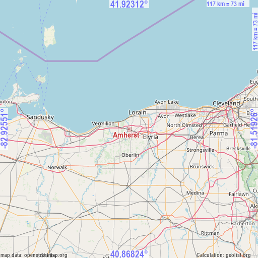
Amherst GPS coordinates[2]
41° 23' 52.152" North, 82° 13' 20.568" West
| Map corner | latitude | longitude |
|---|---|---|
| Upper-left | 41.92312°, | -82.92551° |
| Center: | 41.39782°, | -82.22238° |
| Lower-right: | 40.86824°, | -81.51926° |
| Map W x H: | 117.3×117.3 km | = 72.9×72.9mi |
| max Lat: | 71.29058° ⇑30.3% North |
| Amherst: | 41.39782° |
| min Lat: | ⇓69.7% South 19.06759° |
| min Long | Amherst | max Long |
| -171.73463° | -82.22238° | -66.98998° |
| W 64.8%⇐ | ⇒35.2% E |
Elevation
Elevation of Amherst is 212 m = 696 ft, and this is 82.8 m = 272 ft below average elevation for this country.
| Max E: |
3189 m = 10463 ft | 46.5% |
| Avg. | 294.8 m = 967 ft | |
| Amherst | 212 m = 696 ft | |
Min E: |
-60 m = -197 ft | 53.5% |
See also: United States elevation on elevation.city.
Geographical zone
Amherst is located in North temperate zone (between Tropic of Cancer and the Arctic Circle). Distance of this Northern Tropic circle is 1997.1 km =1240.9 mi to South.| Distance of | km | miles | from Amherst |
|---|---|---|---|
| North Pole | 5404.1 | 3358 | to North |
| Arctic Circle | 2798.2 | 1738.7 | to North |
| Tropic Cancer | 1997.1 | 1240.9 | to South |
| Equator | 4603 | 2860.2 | to South |


Nearby cities:
15 places around Amherst: (largest is in red/bold)
• Avon
16.7 km =10.4 mi,  68°
68°
• Avon Center
18.3 km =11.4 mi, 67°
• Camden
19.1 km =11.9 mi,  201°
201°
• Elyria
10.1 km =6.3 mi,  108°
108°
• Grafton
19.8 km =12.3 mi,  134°
134°
• Lagrange
19.8 km =12.3 mi,  154°
154°
• Lorain
7 km =4.3 mi,  28°
28°
• North Ridgeville
17 km =10.6 mi,  93°
93°
• Oberlin
11.6 km =7.2 mi,  177°
177°
• Sheffield
10.8 km =6.7 mi,  76°
76°
• Sheffield
12.6 km =7.8 mi,  55°
55°
• Sheffield Lake
14.2 km =8.8 mi,  45°
45°
• South Amherst
5.3 km =3.3 mi,  209°
209°
• Vermilion
12.2 km =7.6 mi,  282°
282°
• Vermilion-on-the-Lake
9.1 km =5.7 mi,  291°
291°
Sources, notices
• [Note1] Compared only with cities in United States existing in our database
• [Src1] Map data: © OpenStreetMap contributors (CC-BY-SA)
• [Src2] Other city data from geonames.org with taken over terms of usage.
• [Src3] Geographical zone / Annual Mean Temperature by Robert A. Rohde @ Wikipedia
