Vermilion-on-the-Lake geodata
Vermilion-on-the-Lake (Ohio) is a populated place; located in United States in America/New_York (GMT-4) time zone. With population of 11,006 people, there are 4174 cities with bigger population in this country. Compared to other cities in United States, 70% of cities are located further ↓South; 64.5% of cities are located further ←West and 52.8% of cities have higher elevation than Vermilion-on-the-Lake. Note1
Current local time in Vermilion-on-the-Lake:
02:47 AM, WednesdayDifference from your time zone: hours


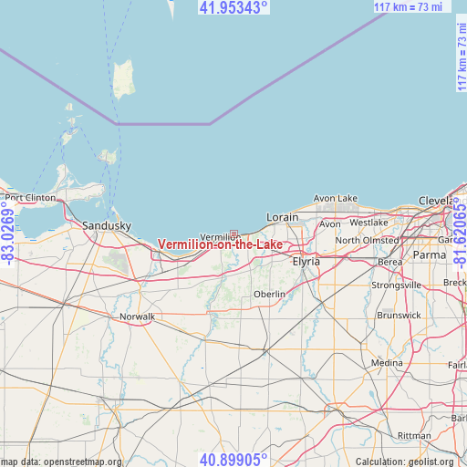
Vermilion-on-the-Lake GPS coordinates[2]
41° 25' 42.168" North, 82° 19' 25.572" West
| Map corner | latitude | longitude |
|---|---|---|
| Upper-left | 41.95343°, | -83.0269° |
| Center: | 41.42838°, | -82.32377° |
| Lower-right: | 40.89905°, | -81.62065° |
| Map W x H: | 117.2×117.2 km | = 72.8×72.8mi |
| max Lat: | 71.29058° ⇑30% North |
| Vermilion-on-the-Lake: | 41.42838° |
| min Lat: | ⇓70% South 19.06759° |
| min Long | Vermilion-on-th | max Long |
| -171.73463° | -82.32377° | -66.98998° |
| W 64.5%⇐ | ⇒35.5% E |
Elevation
Elevation of Vermilion-on-the-Lake is 188 m = 617 ft, and this is 106.8 m = 350 ft below average elevation for this country.
| Max E: |
3189 m = 10463 ft | 52.8% |
| Avg. | 294.8 m = 967 ft | |
| Vermilion-on-the-Lake | 188 m = 617 ft | |
Min E: |
-60 m = -197 ft | 47.2% |
See also: United States elevation on elevation.city.
Geographical zone
Vermilion-on-the-Lake is located in North temperate zone (between Tropic of Cancer and the Arctic Circle). Distance of this Northern Tropic circle is 2000.5 km =1243.1 mi to South.| Distance of | km | miles | from Vermilion-on-the-Lake |
|---|---|---|---|
| North Pole | 5400.7 | 3355.8 | to North |
| Arctic Circle | 2794.8 | 1736.6 | to North |
| Tropic Cancer | 2000.5 | 1243.1 | to South |
| Equator | 4606.4 | 2862.3 | to South |


Nearby cities:
15 places around Vermilion-on-the-Lake: (largest is in red/bold)
• Amherst
9.1 km =5.7 mi,  111°
111°
• Avon
24.2 km =15 mi,  83°
83°
• Berlin Heights
18.2 km =11.3 mi,  230°
230°
• Camden
21.2 km =13.2 mi,  175°
175°
• Collins
23.5 km =14.6 mi,  216°
216°
• Elyria
19.2 km =11.9 mi, 110°
• Huron
19.6 km =12.2 mi,  259°
259°
• Lorain
12.1 km =7.5 mi, 77°
• Oberlin
17.4 km =10.8 mi,  149°
149°
• Sheffield
19 km =11.8 mi,  92°
92°
• Sheffield
19.1 km =11.9 mi, 78°
• Sheffield Lake
19.7 km =12.2 mi,  70°
70°
• South Amherst
10 km =6.2 mi,  144°
144°
• Vermilion
3.5 km =2.2 mi, 258°
• Wakeman
20.3 km =12.6 mi,  198°
198°
Sources, notices
• [Note1] Compared only with cities in United States existing in our database
• [Src1] Map data: © OpenStreetMap contributors (CC-BY-SA)
• [Src2] Other city data from geonames.org with taken over terms of usage.
• [Src3] Geographical zone / Annual Mean Temperature by Robert A. Rohde @ Wikipedia
